Sypniewo geodata
Sypniewo (Greater Poland) is a populated place; located in Poland in Europe/Warsaw (GMT+2) time zone. With population of 1,300 people, there are 2055 cities with bigger population in this country. Compared to other cities in Poland, 89.2% of cities are located further ↓South; 88.8% of cities are located further →East and 64.1% of cities have higher elevation than Sypniewo. Note1


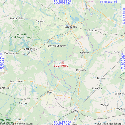
Sypniewo GPS coordinates[2]
53° 28' 5.628" North, 16° 36' 20.988" East
| Map corner | latitude | longitude |
|---|---|---|
| Upper-left | 53.88472°, | 15.90271° |
| Center: | 53.46823°, | 16.60583° |
| Lower-right: | 53.04762°, | 17.30896° |
| Map W x H: | 93.1×93.1 km | = 57.8×57.8mi |
| max Lat: | 54.83135° ⇑10.8% North |
| Sypniewo: | 53.46823° |
| min Lat: | ⇓89.2% South 49.21328° |
| min Long | Sypniewo | max Long |
| 14.20249° | 16.60583° | 24.03723° |
| W 11.2%⇐ | ⇒88.8% E |
Elevation
Elevation of Sypniewo is 136 m = 446 ft, and this is 55.4 m = 182 ft below average elevation for this country.
| Max E: |
974 m = 3196 ft | 64.1% |
| Avg. | 191.4 m = 628 ft | |
| Sypniewo | 136 m = 446 ft | |
Min E: |
-3 m = -10 ft | 35.9% |
See also: Poland elevation on elevation.city.
Geographical zone
Sypniewo is located in North temperate zone (between Tropic of Cancer and the Arctic Circle). Distance of this North polar circle is 1456.1 km =904.8 mi to North.| Distance of | km | miles | from Sypniewo |
|---|---|---|---|
| North Pole | 4062 | 2524 | to North |
| Arctic Circle | 1456.1 | 904.8 | to North |
| Tropic Cancer | 3339.2 | 2074.9 | to South |
| Equator | 5945.1 | 3694.1 | to South |


Nearby cities:
15 places around Sypniewo: (largest is in red/bold)
• Borne Sulinowo
13 km =8.1 mi,  338°
338°
• Czaplinek
26.6 km =16.5 mi,  292°
292°
• Czarne
32.5 km =20.2 mi,  42°
42°
• Jastrowie
15 km =9.3 mi,  110°
110°
• Krajenka
31.8 km =19.8 mi,  126°
126°
• Lędyczek
24.8 km =15.4 mi,  72°
72°
• Okonek
17.9 km =11.1 mi, 65°
• Sitno
21.5 km =13.4 mi,  10°
10°
• Skrzatusz
29.4 km =18.3 mi,  183°
183°
• Szczecinek
27.4 km =17 mi, 13°
• Tarnówka
21.6 km =13.4 mi, 130°
• Wałcz
23 km =14.3 mi,  202°
202°
• Złotów
31.1 km =19.3 mi, 112°
• Łubowo
19.3 km =12 mi,  312°
312°
• Żółtnica
26.5 km =16.5 mi,  30°
30°
Sources, notices
• [Note1] Compared only with cities in Poland existing in our database
• [Src1] Map data: © OpenStreetMap contributors (CC-BY-SA)
• [Src2] Other city data from geonames.org with taken over terms of usage.
• [Src3] Geographical zone / Annual Mean Temperature by Robert A. Rohde @ Wikipedia
