Piława Górna geodata
Piława Górna (Lower Silesia) is a seat of a third-order administrative division; located in Poland in Europe/Warsaw (GMT+2) time zone. With population of 6,736 people, there are 558 cities with bigger population in this country. Compared to other cities in Poland, 62.9% of cities are located further ↑North; 87.7% of cities are located further →East and 87.3% of cities have lower elevation than Piława Górna. Note1
Administrative division(s):
- Level 1: Lower Silesia
- Level 2: Powiat dzierżoniowski
- Level 3: Piława Górna


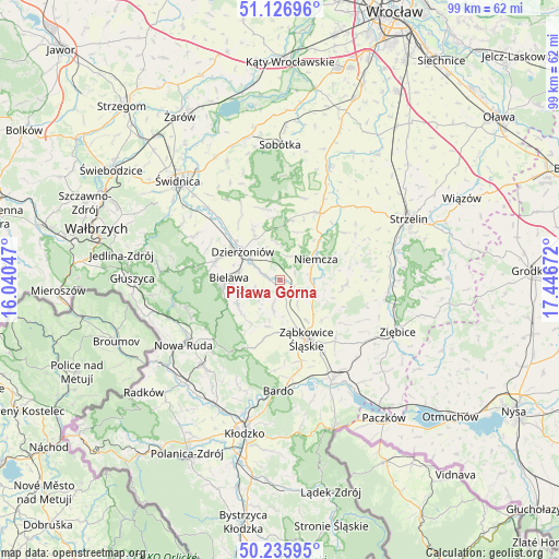
Piława Górna GPS coordinates[2]
50° 41' 0.852" North, 16° 44' 36.924" East
| Map corner | latitude | longitude |
|---|---|---|
| Upper-left | 51.12696°, | 16.04047° |
| Center: | 50.68357°, | 16.74359° |
| Lower-right: | 50.23595°, | 17.44672° |
| Map W x H: | 99.1×99.1 km | = 61.6×61.6mi |
| max Lat: | 54.83135° ⇑62.9% North |
| Piława Górna: | 50.68357° |
| min Lat: | ⇓37.1% South 49.21328° |
| min Long | Piława Górna | max Long |
| 14.20249° | 16.74359° | 24.03723° |
| W 12.3%⇐ | ⇒87.7% E |
Elevation
Elevation of Piława Górna is 304 m = 997 ft, and this is 112.6 m = 369 ft above average elevation for this country.
| Max E: |
974 m = 3196 ft | 12.7% |
| Piława Górna | 304 m 997 ft | |
| Avg. | 191.4 m = 628 ft | |
Min E: |
-3 m = -10 ft | 87.3% |
See also: Poland elevation on elevation.city.
Geographical zone
Piława Górna is located in North temperate zone (between Tropic of Cancer and the Arctic Circle). Distance of this North polar circle is 1765.7 km =1097.2 mi to North.| Distance of | km | miles | from Piława Górna |
|---|---|---|---|
| North Pole | 4371.6 | 2716.4 | to North |
| Arctic Circle | 1765.7 | 1097.2 | to North |
| Tropic Cancer | 3029.6 | 1882.5 | to South |
| Equator | 5635.5 | 3501.7 | to South |


Nearby cities:
15 places around Piława Górna: (largest is in red/bold)
• Bielawa
8.5 km =5.3 mi,  275°
275°
• Bobolice
10.5 km =6.5 mi,  129°
129°
• Budzów
10.3 km =6.4 mi,  193°
193°
• Ciepłowody
11.7 km =7.3 mi,  94°
94°
• Dobrocin
6.2 km =3.9 mi,  335°
335°
• Dzierżoniów
8.2 km =5.1 mi,  307°
307°
• Jodłownik
10.1 km =6.3 mi,  245°
245°
• Niemcza
7.7 km =4.8 mi,  57°
57°
• Ostroszowice
8.4 km =5.2 mi,  240°
240°
• Pieszyce
11.8 km =7.3 mi,  286°
286°
• Stoszowice
9.3 km =5.8 mi,  182°
182°
• Tarnów
12.1 km =7.5 mi,  164°
164°
• Uciechów
9 km =5.6 mi,  331°
331°
• Wilków Wielki
10.7 km =6.6 mi,  43°
43°
• Ząbkowice Śląskie
11.5 km =7.1 mi, 155°
Sources, notices
• [Note1] Compared only with cities in Poland existing in our database
• [Src1] Map data: © OpenStreetMap contributors (CC-BY-SA)
• [Src2] Other city data from geonames.org with taken over terms of usage.
• [Src3] Geographical zone / Annual Mean Temperature by Robert A. Rohde @ Wikipedia
