Stoszowice geodata
Stoszowice (Lower Silesia) is a populated place; located in Poland in Europe/Warsaw (GMT+2) time zone. With population of 1,100 people, there are 2307 cities with bigger population in this country. Compared to other cities in Poland, 65.1% of cities are located further ↑North; 87.7% of cities are located further →East and 85.8% of cities have lower elevation than Stoszowice. Note1


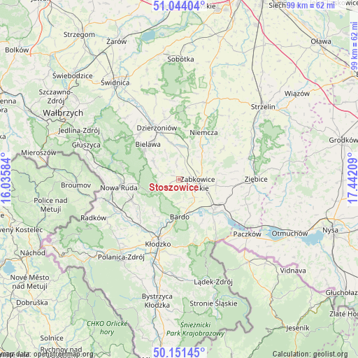
Stoszowice GPS coordinates[2]
50° 35' 59.496" North, 16° 44' 20.256" East
| Map corner | latitude | longitude |
|---|---|---|
| Upper-left | 51.04404°, | 16.03584° |
| Center: | 50.59986°, | 16.73896° |
| Lower-right: | 50.15145°, | 17.44209° |
| Map W x H: | 99.2×99.2 km | = 61.6×61.6mi |
| max Lat: | 54.83135° ⇑65.1% North |
| Stoszowice: | 50.59986° |
| min Lat: | ⇓34.9% South 49.21328° |
| min Long | Stoszowice | max Long |
| 14.20249° | 16.73896° | 24.03723° |
| W 12.3%⇐ | ⇒87.7% E |
Elevation
Elevation of Stoszowice is 294 m = 965 ft, and this is 102.6 m = 337 ft above average elevation for this country.
| Max E: |
974 m = 3196 ft | 14.2% |
| Stoszowice | 294 m 965 ft | |
| Avg. | 191.4 m = 628 ft | |
Min E: |
-3 m = -10 ft | 85.8% |
See also: Poland elevation on elevation.city.
Geographical zone
Stoszowice is located in North temperate zone (between Tropic of Cancer and the Arctic Circle). Distance of this North polar circle is 1775 km =1102.9 mi to North.| Distance of | km | miles | from Stoszowice |
|---|---|---|---|
| North Pole | 4380.9 | 2722.2 | to North |
| Arctic Circle | 1775 | 1102.9 | to North |
| Tropic Cancer | 3020.3 | 1876.7 | to South |
| Equator | 5626.2 | 3496 | to South |


Nearby cities:
15 places around Stoszowice: (largest is in red/bold)
• Bardo
10.4 km =6.5 mi,  179°
179°
• Bielawa
13 km =8.1 mi,  321°
321°
• Bobolice
8.8 km =5.5 mi,  73°
73°
• Bozkow
15.1 km =9.4 mi,  230°
230°
• Brzeźnica
6.7 km =4.2 mi, 184°
• Budzów
2.1 km =1.3 mi,  250°
250°
• Ciepłowody
14.6 km =9.1 mi,  55°
55°
• Jodłownik
10.2 km =6.3 mi,  299°
299°
• Kamieniec Ząbkowicki
12.9 km =8 mi,  129°
129°
• Niemcza
15 km =9.3 mi,  27°
27°
• Ostroszowice
8.7 km =5.4 mi,  306°
306°
• Piława Górna
9.3 km =5.8 mi,  2°
2°
• Przyłęk
9.4 km =5.8 mi,  162°
162°
• Tarnów
4.3 km =2.7 mi,  123°
123°
• Ząbkowice Śląskie
5.3 km =3.3 mi,  102°
102°
Sources, notices
• [Note1] Compared only with cities in Poland existing in our database
• [Src1] Map data: © OpenStreetMap contributors (CC-BY-SA)
• [Src2] Other city data from geonames.org with taken over terms of usage.
• [Src3] Geographical zone / Annual Mean Temperature by Robert A. Rohde @ Wikipedia
