Ciepłowody geodata
Ciepłowody (Lower Silesia) is a populated place; located in Poland in Europe/Warsaw (GMT+2) time zone. With population of 1,200 people, there are 2164 cities with bigger population in this country. Compared to other cities in Poland, 63.2% of cities are located further ↑North; 85.9% of cities are located further →East and 81.4% of cities have lower elevation than Ciepłowody. Note1


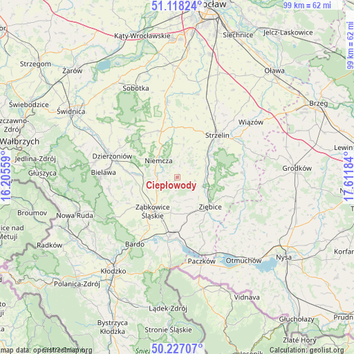
Ciepłowody GPS coordinates[2]
50° 40' 29.172" North, 16° 54' 31.356" East
| Map corner | latitude | longitude |
|---|---|---|
| Upper-left | 51.11824°, | 16.20559° |
| Center: | 50.67477°, | 16.90871° |
| Lower-right: | 50.22707°, | 17.61184° |
| Map W x H: | 99.1×99.1 km | = 61.6×61.6mi |
| max Lat: | 54.83135° ⇑63.2% North |
| Ciepłowody: | 50.67477° |
| min Lat: | ⇓36.8% South 49.21328° |
| min Long | Ciepłowody | max Long |
| 14.20249° | 16.90871° | 24.03723° |
| W 14.1%⇐ | ⇒85.9% E |
Elevation
Elevation of Ciepłowody is 272 m = 892 ft, and this is 80.6 m = 264 ft above average elevation for this country.
| Max E: |
974 m = 3196 ft | 18.6% |
| Ciepłowody | 272 m 892 ft | |
| Avg. | 191.4 m = 628 ft | |
Min E: |
-3 m = -10 ft | 81.4% |
See also: Poland elevation on elevation.city.
Geographical zone
Ciepłowody is located in North temperate zone (between Tropic of Cancer and the Arctic Circle). Distance of this North polar circle is 1766.7 km =1097.8 mi to North.| Distance of | km | miles | from Ciepłowody |
|---|---|---|---|
| North Pole | 4372.6 | 2717 | to North |
| Arctic Circle | 1766.7 | 1097.8 | to North |
| Tropic Cancer | 3028.6 | 1881.9 | to South |
| Equator | 5634.5 | 3501.1 | to South |


Nearby cities:
15 places around Ciepłowody: (largest is in red/bold)
• Bobolice
6.8 km =4.2 mi,  211°
211°
• Dobrocin
15.7 km =9.8 mi,  294°
294°
• Henryków
7.5 km =4.7 mi,  108°
108°
• Kamieniec Ząbkowicki
16.7 km =10.4 mi,  187°
187°
• Kondratowice
11.1 km =6.9 mi,  9°
9°
• Niedźwiedź
16.6 km =10.3 mi,  156°
156°
• Niemcza
7.2 km =4.5 mi,  314°
314°
• Piława Górna
11.7 km =7.3 mi,  274°
274°
• Stoszowice
14.6 km =9.1 mi,  235°
235°
• Strzelin
16.2 km =10.1 mi,  42°
42°
• Tarnów
13.6 km =8.5 mi,  217°
217°
• Wilków Wielki
9.7 km =6 mi,  334°
334°
• Ziębice
12.4 km =7.7 mi,  131°
131°
• Ząbkowice Śląskie
11.6 km =7.2 mi, 215°
• Łagiewniki
13.7 km =8.5 mi,  340°
340°
Sources, notices
• [Note1] Compared only with cities in Poland existing in our database
• [Src1] Map data: © OpenStreetMap contributors (CC-BY-SA)
• [Src2] Other city data from geonames.org with taken over terms of usage.
• [Src3] Geographical zone / Annual Mean Temperature by Robert A. Rohde @ Wikipedia
