Raszowa geodata
Raszowa (Opole Voivodeship) is a populated place; located in Poland in Europe/Warsaw (GMT+2) time zone. With population of 1,041 people, there are 2412 cities with bigger population in this country. Compared to other cities in Poland, 69.5% of cities are located further ↑North; 72.8% of cities are located further →East and 56% of cities have lower elevation than Raszowa. Note1


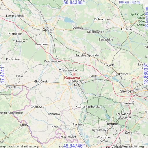
Raszowa GPS coordinates[2]
50° 23' 52.044" North, 18° 10' 37.992" East
| Map corner | latitude | longitude |
|---|---|---|
| Upper-left | 50.84388°, | 17.4741° |
| Center: | 50.39779°, | 18.17722° |
| Lower-right: | 49.94746°, | 18.88035° |
| Map W x H: | 99.7×99.7 km | = 62×62mi |
| max Lat: | 54.83135° ⇑69.5% North |
| Raszowa: | 50.39779° |
| min Lat: | ⇓30.5% South 49.21328° |
| min Long | Raszowa | max Long |
| 14.20249° | 18.17722° | 24.03723° |
| W 27.2%⇐ | ⇒72.8% E |
Elevation
Elevation of Raszowa is 188 m = 617 ft, and this is 3.4 m = 11 ft below average elevation for this country.
| Max E: |
974 m = 3196 ft | 44% |
| Avg. | 191.4 m = 628 ft | |
| Raszowa | 188 m = 617 ft | |
Min E: |
-3 m = -10 ft | 56% |
See also: Poland elevation on elevation.city.
Geographical zone
Raszowa is located in North temperate zone (between Tropic of Cancer and the Arctic Circle). Distance of this North polar circle is 1797.5 km =1116.9 mi to North.| Distance of | km | miles | from Raszowa |
|---|---|---|---|
| North Pole | 4403.4 | 2736.1 | to North |
| Arctic Circle | 1797.5 | 1116.9 | to North |
| Tropic Cancer | 2997.8 | 1862.7 | to South |
| Equator | 5603.7 | 3482 | to South |


Nearby cities:
15 places around Raszowa: (largest is in red/bold)
• Dobieszowice
11.4 km =7.1 mi,  249°
249°
• Januszkowice
2.9 km =1.8 mi,  257°
257°
• Komorno
8.6 km =5.3 mi,  238°
238°
• Koźle
7.3 km =4.5 mi,  199°
199°
• Kędzierzyn-Koźle
6.4 km =4 mi,  146°
146°
• Leśnica
3.7 km =2.3 mi,  10°
10°
• Poborszów
7.1 km =4.4 mi, 249°
• Pokrzywnica
10.9 km =6.8 mi,  228°
228°
• Reńska Wieś
9.8 km =6.1 mi, 201°
• Rozwadza
6.9 km =4.3 mi,  306°
306°
• Sławięcice
10.6 km =6.6 mi,  105°
105°
• Ujazd
12.2 km =7.6 mi,  94°
94°
• Walce
12.6 km =7.8 mi, 257°
• Większyce
8.6 km =5.3 mi,  218°
218°
• Zdzieszowice
4.9 km =3 mi, 308°
Sources, notices
• [Note1] Compared only with cities in Poland existing in our database
• [Src1] Map data: © OpenStreetMap contributors (CC-BY-SA)
• [Src2] Other city data from geonames.org with taken over terms of usage.
• [Src3] Geographical zone / Annual Mean Temperature by Robert A. Rohde @ Wikipedia
