Zdzieszowice geodata
Zdzieszowice (Opole Voivodeship) is a seat of a third-order administrative division; located in Poland in Europe/Warsaw (GMT+2) time zone. With population of 13,401 people, there are 365 cities with bigger population in this country. Compared to other cities in Poland, 69% of cities are located further ↑North; 73.8% of cities are located further →East and 55% of cities have lower elevation than Zdzieszowice. Note1
Administrative division(s):
- Level 1: Opole Voivodeship
- Level 2: Powiat krapkowicki
- Level 3: Zdzieszowice


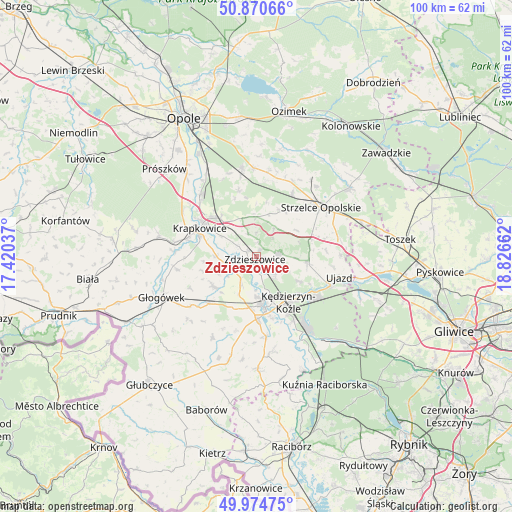
Zdzieszowice GPS coordinates[2]
50° 25' 29.352" North, 18° 7' 24.564" East
| Map corner | latitude | longitude |
|---|---|---|
| Upper-left | 50.87066°, | 17.42037° |
| Center: | 50.42482°, | 18.12349° |
| Lower-right: | 49.97475°, | 18.82662° |
| Map W x H: | 99.6×99.6 km | = 61.9×61.9mi |
| max Lat: | 54.83135° ⇑69% North |
| Zdzieszowice: | 50.42482° |
| min Lat: | ⇓31% South 49.21328° |
| min Long | Zdzieszowice | max Long |
| 14.20249° | 18.12349° | 24.03723° |
| W 26.2%⇐ | ⇒73.8% E |
Elevation
Elevation of Zdzieszowice is 185 m = 607 ft, and this is 6.4 m = 21 ft below average elevation for this country.
| Max E: |
974 m = 3196 ft | 45% |
| Avg. | 191.4 m = 628 ft | |
| Zdzieszowice | 185 m = 607 ft | |
Min E: |
-3 m = -10 ft | 55% |
See also: Poland elevation on elevation.city.
Geographical zone
Zdzieszowice is located in North temperate zone (between Tropic of Cancer and the Arctic Circle). Distance of this North polar circle is 1794.5 km =1115.1 mi to North.| Distance of | km | miles | from Zdzieszowice |
|---|---|---|---|
| North Pole | 4400.3 | 2734.2 | to North |
| Arctic Circle | 1794.5 | 1115.1 | to North |
| Tropic Cancer | 3000.8 | 1864.6 | to South |
| Equator | 5606.7 | 3483.8 | to South |


Nearby cities:
15 places around Zdzieszowice: (largest is in red/bold)
• Dobieszowice
9.8 km =6.1 mi,  224°
224°
• Gogolin
10.5 km =6.5 mi,  315°
315°
• Januszkowice
3.8 km =2.4 mi,  165°
165°
• Komorno
8.3 km =5.2 mi,  204°
204°
• Koźle
10 km =6.2 mi, 171°
• Krapkowice
12.5 km =7.8 mi,  296°
296°
• Kędzierzyn-Koźle
11.1 km =6.9 mi,  138°
138°
• Leśnica
4.5 km =2.8 mi,  81°
81°
• Poborszów
6.2 km =3.9 mi,  207°
207°
• Pokrzywnica
11.1 km =6.9 mi, 203°
• Raszowa
4.9 km =3 mi,  128°
128°
• Reńska Wieś
12.1 km =7.5 mi,  179°
179°
• Rozwadza
2 km =1.2 mi, 303°
• Walce
10.2 km =6.3 mi,  235°
235°
• Większyce
9.9 km =6.2 mi,  188°
188°
Sources, notices
• [Note1] Compared only with cities in Poland existing in our database
• [Src1] Map data: © OpenStreetMap contributors (CC-BY-SA)
• [Src2] Other city data from geonames.org with taken over terms of usage.
• [Src3] Geographical zone / Annual Mean Temperature by Robert A. Rohde @ Wikipedia
