Leśnica geodata
Leśnica (Opole Voivodeship) is a seat of a third-order administrative division; located in Poland in Europe/Warsaw (GMT+2) time zone. With population of 2,897 people, there are 1095 cities with bigger population in this country. Compared to other cities in Poland, 68.8% of cities are located further ↑North; 72.8% of cities are located further →East and 67.7% of cities have lower elevation than Leśnica. Note1


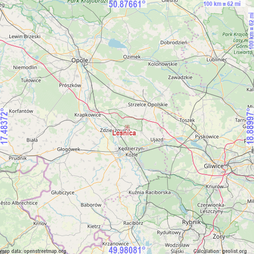
Leśnica GPS coordinates[2]
50° 25' 50.988" North, 18° 11' 12.624" East
| Map corner | latitude | longitude |
|---|---|---|
| Upper-left | 50.87661°, | 17.48372° |
| Center: | 50.43083°, | 18.18684° |
| Lower-right: | 49.98081°, | 18.88997° |
| Map W x H: | 99.6×99.6 km | = 61.9×61.9mi |
| max Lat: | 54.83135° ⇑68.8% North |
| Leśnica: | 50.43083° |
| min Lat: | ⇓31.2% South 49.21328° |
| min Long | Leśnica | max Long |
| 14.20249° | 18.18684° | 24.03723° |
| W 27.2%⇐ | ⇒72.8% E |
Elevation
Elevation of Leśnica is 222 m = 728 ft, and this is 30.6 m = 100 ft above average elevation for this country.
| Max E: |
974 m = 3196 ft | 32.3% |
| Leśnica | 222 m 728 ft | |
| Avg. | 191.4 m = 628 ft | |
Min E: |
-3 m = -10 ft | 67.7% |
See also: Poland elevation on elevation.city.
Geographical zone
Leśnica is located in North temperate zone (between Tropic of Cancer and the Arctic Circle). Distance of this North polar circle is 1793.8 km =1114.6 mi to North.| Distance of | km | miles | from Leśnica |
|---|---|---|---|
| North Pole | 4399.7 | 2733.8 | to North |
| Arctic Circle | 1793.8 | 1114.6 | to North |
| Tropic Cancer | 3001.5 | 1865 | to South |
| Equator | 5607.4 | 3484.3 | to South |


Nearby cities:
15 places around Leśnica: (largest is in red/bold)
• Dobieszowice
13.7 km =8.5 mi,  236°
236°
• Gogolin
13.6 km =8.5 mi,  300°
300°
• Januszkowice
5.6 km =3.5 mi,  219°
219°
• Komorno
11.4 km =7.1 mi, 224°
• Koźle
11 km =6.8 mi,  196°
196°
• Kędzierzyn-Koźle
9.4 km =5.8 mi,  162°
162°
• Poborszów
9.6 km =6 mi,  229°
229°
• Raszowa
3.7 km =2.3 mi,  190°
190°
• Reńska Wieś
13.5 km =8.4 mi, 198°
• Rozwadza
6.2 km =3.9 mi,  274°
274°
• Strzelce Opolskie
12 km =7.5 mi,  42°
42°
• Sławięcice
11.6 km =7.2 mi,  124°
124°
• Ujazd
12.4 km =7.7 mi,  111°
111°
• Większyce
12.1 km =7.5 mi,  209°
209°
• Zdzieszowice
4.5 km =2.8 mi,  261°
261°
Sources, notices
• [Note1] Compared only with cities in Poland existing in our database
• [Src1] Map data: © OpenStreetMap contributors (CC-BY-SA)
• [Src2] Other city data from geonames.org with taken over terms of usage.
• [Src3] Geographical zone / Annual Mean Temperature by Robert A. Rohde @ Wikipedia
