Zawadzkie geodata
Zawadzkie (Opole Voivodeship) is a seat of a third-order administrative division; located in Poland in Europe/Warsaw (GMT+2) time zone. With population of 8,439 people, there are 498 cities with bigger population in this country. Compared to other cities in Poland, 64.9% of cities are located further ↑North; 68.4% of cities are located further →East and 64.1% of cities have lower elevation than Zawadzkie. Note1
Administrative division(s):
- Level 1: Opole Voivodeship
- Level 2: Powiat strzelecki
- Level 3: Zawadzkie


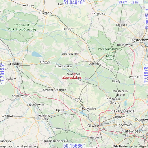
Zawadzkie GPS coordinates[2]
50° 36' 18.108" North, 18° 29' 4.812" East
| Map corner | latitude | longitude |
|---|---|---|
| Upper-left | 51.04916°, | 17.78155° |
| Center: | 50.60503°, | 18.48467° |
| Lower-right: | 50.15666°, | 19.1878° |
| Map W x H: | 99.2×99.2 km | = 61.6×61.6mi |
| max Lat: | 54.83135° ⇑64.9% North |
| Zawadzkie: | 50.60503° |
| min Lat: | ⇓35.1% South 49.21328° |
| min Long | Zawadzkie | max Long |
| 14.20249° | 18.48467° | 24.03723° |
| W 31.6%⇐ | ⇒68.4% E |
Elevation
Elevation of Zawadzkie is 212 m = 696 ft, and this is 20.6 m = 68 ft above average elevation for this country.
| Max E: |
974 m = 3196 ft | 35.9% |
| Zawadzkie | 212 m 696 ft | |
| Avg. | 191.4 m = 628 ft | |
Min E: |
-3 m = -10 ft | 64.1% |
See also: Poland elevation on elevation.city.
Geographical zone
Zawadzkie is located in North temperate zone (between Tropic of Cancer and the Arctic Circle). Distance of this North polar circle is 1774.4 km =1102.6 mi to North.| Distance of | km | miles | from Zawadzkie |
|---|---|---|---|
| North Pole | 4380.3 | 2721.8 | to North |
| Arctic Circle | 1774.4 | 1102.6 | to North |
| Tropic Cancer | 3020.8 | 1877 | to South |
| Equator | 5626.8 | 3496.3 | to South |


Nearby cities:
15 places around Zawadzkie: (largest is in red/bold)
• Ciasna
18.7 km =11.6 mi,  27°
27°
• Dobrodzień
14 km =8.7 mi,  348°
348°
• Gwoździany
13.4 km =8.3 mi,  13°
13°
• Jemielnica
10 km =6.2 mi,  228°
228°
• Kolonowskie
8.9 km =5.5 mi,  307°
307°
• Krupski Młyn
10.3 km =6.4 mi,  109°
109°
• Lubliniec
15.8 km =9.8 mi,  63°
63°
• Ozimek
20.8 km =12.9 mi,  293°
293°
• Pawonków
12.1 km =7.5 mi, 34°
• Strzelce Opolskie
16.7 km =10.4 mi, 231°
• Toszek
17 km =10.6 mi,  171°
171°
• Tworóg
18.3 km =11.4 mi,  116°
116°
• Wielowieś
14.1 km =8.8 mi,  138°
138°
• Zębowice
20.1 km =12.5 mi,  330°
330°
• Łaziska
8.7 km =5.4 mi,  256°
256°
Sources, notices
• [Note1] Compared only with cities in Poland existing in our database
• [Src1] Map data: © OpenStreetMap contributors (CC-BY-SA)
• [Src2] Other city data from geonames.org with taken over terms of usage.
• [Src3] Geographical zone / Annual Mean Temperature by Robert A. Rohde @ Wikipedia
