Ujazd geodata
Ujazd (Opole Voivodeship) is a seat of a third-order administrative division; located in Poland in Europe/Warsaw (GMT+2) time zone. With population of 1,638 people, there are 1728 cities with bigger population in this country. Compared to other cities in Poland, 69.7% of cities are located further ↑North; 70.5% of cities are located further →East and 58.3% of cities have lower elevation than Ujazd. Note1


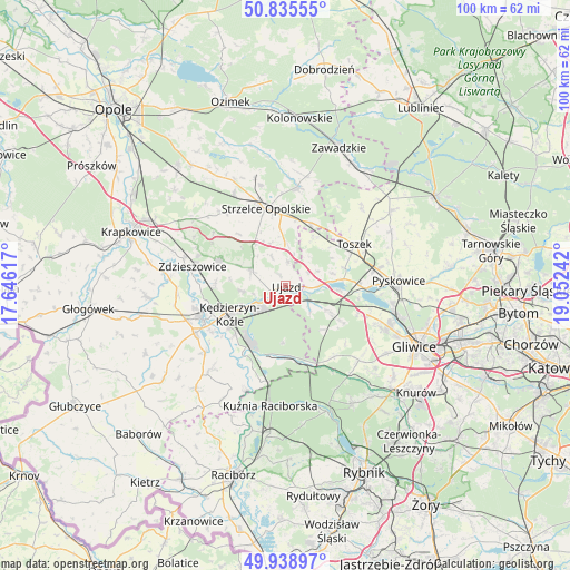
Ujazd GPS coordinates[2]
50° 23' 21.768" North, 18° 20' 57.444" East
| Map corner | latitude | longitude |
|---|---|---|
| Upper-left | 50.83555°, | 17.64617° |
| Center: | 50.38938°, | 18.34929° |
| Lower-right: | 49.93897°, | 19.05242° |
| Map W x H: | 99.7×99.7 km | = 62×62mi |
| max Lat: | 54.83135° ⇑69.7% North |
| Ujazd: | 50.38938° |
| min Lat: | ⇓30.3% South 49.21328° |
| min Long | Ujazd | max Long |
| 14.20249° | 18.34929° | 24.03723° |
| W 29.5%⇐ | ⇒70.5% E |
Elevation
Elevation of Ujazd is 194 m = 636 ft, and this is 2.6 m = 9 ft above average elevation for this country.
| Max E: |
974 m = 3196 ft | 41.7% |
| Ujazd | 194 m 636 ft | |
| Avg. | 191.4 m = 628 ft | |
Min E: |
-3 m = -10 ft | 58.3% |
See also: Poland elevation on elevation.city.
Geographical zone
Ujazd is located in North temperate zone (between Tropic of Cancer and the Arctic Circle). Distance of this North polar circle is 1798.4 km =1117.5 mi to North.| Distance of | km | miles | from Ujazd |
|---|---|---|---|
| North Pole | 4404.3 | 2736.7 | to North |
| Arctic Circle | 1798.4 | 1117.5 | to North |
| Tropic Cancer | 2996.9 | 1862.2 | to South |
| Equator | 5602.8 | 3481.4 | to South |


Nearby cities:
15 places around Ujazd: (largest is in red/bold)
• Bierawa
14.3 km =8.9 mi,  212°
212°
• Cisek
15.9 km =9.9 mi,  221°
221°
• Dziergowice
16.9 km =10.5 mi,  195°
195°
• Januszkowice
15.1 km =9.4 mi,  271°
271°
• Kleszczów
13.4 km =8.3 mi,  110°
110°
• Koźle
15.8 km =9.8 mi,  247°
247°
• Kędzierzyn-Koźle
9.8 km =6.1 mi,  243°
243°
• Leśnica
12.4 km =7.7 mi,  291°
291°
• Lubieszów
15.5 km =9.6 mi, 202°
• Raszowa
12.2 km =7.6 mi, 274°
• Rudziniec
5.8 km =3.6 mi,  133°
133°
• Strzelce Opolskie
13.9 km =8.6 mi,  345°
345°
• Sławięcice
2.7 km =1.7 mi,  225°
225°
• Toszek
14.2 km =8.8 mi,  59°
59°
• Zdzieszowice
16.5 km =10.3 mi,  283°
283°
Sources, notices
• [Note1] Compared only with cities in Poland existing in our database
• [Src1] Map data: © OpenStreetMap contributors (CC-BY-SA)
• [Src2] Other city data from geonames.org with taken over terms of usage.
• [Src3] Geographical zone / Annual Mean Temperature by Robert A. Rohde @ Wikipedia
