Sławięcice geodata
Sławięcice (Opole Voivodeship) is a section of populated place; located in Poland in Europe/Warsaw (GMT+2) time zone. With population of 2,770 people, there are 1138 cities with bigger population in this country. Compared to other cities in Poland, 70.3% of cities are located further ↑North; 71% of cities are located further →East and 56.5% of cities have lower elevation than Sławięcice. Note1
Administrative division(s):
- Level 1: Opole Voivodeship
- Level 2: Powiat kędzierzyńsko-kozielski
- Level 3: Kędzierzyn-Koźle


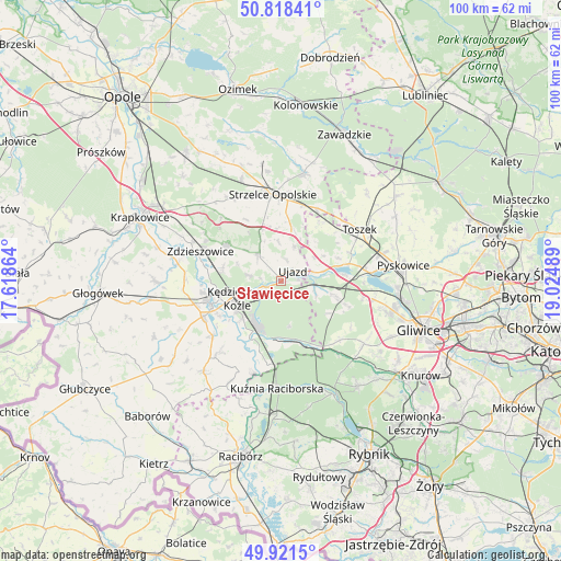
Sławięcice GPS coordinates[2]
50° 22' 19.452" North, 18° 19' 18.336" East
| Map corner | latitude | longitude |
|---|---|---|
| Upper-left | 50.81841°, | 17.61864° |
| Center: | 50.37207°, | 18.32176° |
| Lower-right: | 49.9215°, | 19.02489° |
| Map W x H: | 99.7×99.7 km | = 62×62mi |
| max Lat: | 54.83135° ⇑70.3% North |
| Sławięcice: | 50.37207° |
| min Lat: | ⇓29.7% South 49.21328° |
| min Long | Sławięcice | max Long |
| 14.20249° | 18.32176° | 24.03723° |
| W 29%⇐ | ⇒71% E |
Elevation
Elevation of Sławięcice is 189 m = 620 ft, and this is 2.4 m = 8 ft below average elevation for this country.
| Max E: |
974 m = 3196 ft | 43.5% |
| Avg. | 191.4 m = 628 ft | |
| Sławięcice | 189 m = 620 ft | |
Min E: |
-3 m = -10 ft | 56.5% |
See also: Poland elevation on elevation.city.
Geographical zone
Sławięcice is located in North temperate zone (between Tropic of Cancer and the Arctic Circle). Distance of this North polar circle is 1800.3 km =1118.7 mi to North.| Distance of | km | miles | from Sławięcice |
|---|---|---|---|
| North Pole | 4406.2 | 2737.9 | to North |
| Arctic Circle | 1800.3 | 1118.7 | to North |
| Tropic Cancer | 2994.9 | 1860.9 | to South |
| Equator | 5600.8 | 3480.2 | to South |


Nearby cities:
15 places around Sławięcice: (largest is in red/bold)
• Bierawa
11.6 km =7.2 mi,  209°
209°
• Cisek
13.2 km =8.2 mi,  220°
220°
• Dziergowice
14.6 km =9.1 mi,  189°
189°
• Januszkowice
13.3 km =8.3 mi,  279°
279°
• Kleszczów
14.8 km =9.2 mi,  100°
100°
• Koźle
13.3 km =8.3 mi,  252°
252°
• Kędzierzyn-Koźle
7.2 km =4.5 mi, 249°
• Leśnica
11.6 km =7.2 mi,  304°
304°
• Lubieszów
13 km =8.1 mi,  197°
197°
• Raszowa
10.6 km =6.6 mi,  285°
285°
• Reńska Wieś
15.2 km =9.4 mi, 245°
• Rudziniec
6.5 km =4 mi,  108°
108°
• Strzelce Opolskie
15.5 km =9.6 mi,  354°
354°
• Ujazd
2.7 km =1.7 mi,  45°
45°
• Zdzieszowice
15.2 km =9.4 mi, 292°
Sources, notices
• [Note1] Compared only with cities in Poland existing in our database
• [Src1] Map data: © OpenStreetMap contributors (CC-BY-SA)
• [Src2] Other city data from geonames.org with taken over terms of usage.
• [Src3] Geographical zone / Annual Mean Temperature by Robert A. Rohde @ Wikipedia
