Grodziec geodata
Grodziec (Greater Poland) is a seat of a third-order administrative division; located in Poland in Europe/Warsaw (GMT+2) time zone. With population of 1,400 people, there are 1959 cities with bigger population in this country. Compared to other cities in Poland, 66.3% of cities are located further ↓South; 74.7% of cities are located further →East and 77.2% of cities have higher elevation than Grodziec. Note1


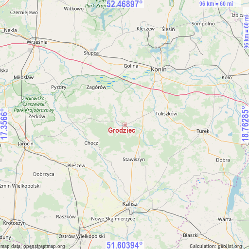
Grodziec GPS coordinates[2]
52° 2' 18.78" North, 18° 3' 34.992" East
| Map corner | latitude | longitude |
|---|---|---|
| Upper-left | 52.46897°, | 17.3566° |
| Center: | 52.03855°, | 18.05972° |
| Lower-right: | 51.60394°, | 18.76285° |
| Map W x H: | 96.2×96.2 km | = 59.8×59.8mi |
| max Lat: | 54.83135° ⇑33.7% North |
| Grodziec: | 52.03855° |
| min Lat: | ⇓66.3% South 49.21328° |
| min Long | Grodziec | max Long |
| 14.20249° | 18.05972° | 24.03723° |
| W 25.3%⇐ | ⇒74.7% E |
Elevation
Elevation of Grodziec is 105 m = 344 ft, and this is 86.4 m = 283 ft below average elevation for this country.
| Max E: |
974 m = 3196 ft | 77.2% |
| Avg. | 191.4 m = 628 ft | |
| Grodziec | 105 m = 344 ft | |
Min E: |
-3 m = -10 ft | 22.8% |
See also: Poland elevation on elevation.city.
Geographical zone
Grodziec is located in North temperate zone (between Tropic of Cancer and the Arctic Circle). Distance of this North polar circle is 1615 km =1003.5 mi to North.| Distance of | km | miles | from Grodziec |
|---|---|---|---|
| North Pole | 4220.9 | 2622.7 | to North |
| Arctic Circle | 1615 | 1003.5 | to North |
| Tropic Cancer | 3180.2 | 1976.1 | to South |
| Equator | 5786.1 | 3595.3 | to South |


Nearby cities:
15 places around Grodziec: (largest is in red/bold)
• Blizanów
15.4 km =9.6 mi,  192°
192°
• Broniszewice
18.5 km =11.5 mi,  244°
244°
• Chocz
14.7 km =9.1 mi, 241°
• Gizałki
19.9 km =12.4 mi,  271°
271°
• Kościelec
18 km =11.2 mi,  143°
143°
• Lądek
20.9 km =13 mi,  334°
334°
• Rychwał
8.1 km =5 mi,  63°
63°
• Rzgów Pierwszy
12.6 km =7.8 mi,  356°
356°
• Stare Miasto
18.9 km =11.7 mi,  34°
34°
• Stawiszyn
13.9 km =8.6 mi,  165°
165°
• Tarnowa
22.3 km =13.9 mi,  73°
73°
• Tomice
22.2 km =13.8 mi,  278°
278°
• Tuliszków
16.7 km =10.4 mi,  75°
75°
• Zagórów
18.3 km =11.4 mi,  322°
322°
• Żelazków
22 km =13.7 mi,  159°
159°
Sources, notices
• [Note1] Compared only with cities in Poland existing in our database
• [Src1] Map data: © OpenStreetMap contributors (CC-BY-SA)
• [Src2] Other city data from geonames.org with taken over terms of usage.
• [Src3] Geographical zone / Annual Mean Temperature by Robert A. Rohde @ Wikipedia
