Nekla geodata
Nekla (Greater Poland) is a seat of a third-order administrative division; located in Poland in Europe/Warsaw (GMT+2) time zone. With population of 3,351 people, there are 955 cities with bigger population in this country. Compared to other cities in Poland, 74% of cities are located further ↓South; 80.6% of cities are located further →East and 74% of cities have higher elevation than Nekla. Note1


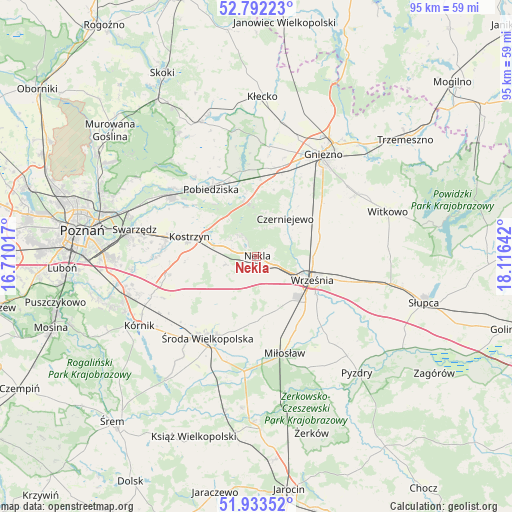
Nekla GPS coordinates[2]
52° 21' 53.856" North, 17° 24' 47.844" East
| Map corner | latitude | longitude |
|---|---|---|
| Upper-left | 52.79223°, | 16.71017° |
| Center: | 52.36496°, | 17.41329° |
| Lower-right: | 51.93352°, | 18.11642° |
| Map W x H: | 95.5×95.5 km | = 59.3×59.3mi |
| max Lat: | 54.83135° ⇑26% North |
| Nekla: | 52.36496° |
| min Lat: | ⇓74% South 49.21328° |
| min Long | Nekla | max Long |
| 14.20249° | 17.41329° | 24.03723° |
| W 19.4%⇐ | ⇒80.6% E |
Elevation
Elevation of Nekla is 113 m = 371 ft, and this is 78.4 m = 257 ft below average elevation for this country.
| Max E: |
974 m = 3196 ft | 74% |
| Avg. | 191.4 m = 628 ft | |
| Nekla | 113 m = 371 ft | |
Min E: |
-3 m = -10 ft | 26% |
See also: Poland elevation on elevation.city.
Geographical zone
Nekla is located in North temperate zone (between Tropic of Cancer and the Arctic Circle). Distance of this North polar circle is 1578.7 km =981 mi to North.| Distance of | km | miles | from Nekla |
|---|---|---|---|
| North Pole | 4184.6 | 2600.2 | to North |
| Arctic Circle | 1578.7 | 981 | to North |
| Tropic Cancer | 3216.5 | 1998.6 | to South |
| Equator | 5822.4 | 3617.9 | to South |


Nearby cities:
15 places around Nekla: (largest is in red/bold)
• Czerniejewo
8.6 km =5.3 mi,  37°
37°
• Dominowo
9 km =5.6 mi,  204°
204°
• Gniezno
22.1 km =13.7 mi,  31°
31°
• Grabowo Królewskie
19.7 km =12.2 mi,  134°
134°
• Kleszczewo
16.8 km =10.4 mi,  258°
258°
• Kostrzyn
13.1 km =8.1 mi,  286°
286°
• Kołaczkowo
21.8 km =13.5 mi,  138°
138°
• Miłosław
18.7 km =11.6 mi,  163°
163°
• Niechanowo
21.1 km =13.1 mi,  58°
58°
• Pobiedziska
15.1 km =9.4 mi,  325°
325°
• Swarzędz
22.9 km =14.2 mi,  283°
283°
• Słupia Wiełka
21 km =13 mi,  218°
218°
• Września
11.2 km =7 mi,  113°
113°
• Łubowo
16.5 km =10.3 mi,  9°
9°
• Środa Wielkopolska
17.8 km =11.1 mi,  211°
211°
Sources, notices
• [Note1] Compared only with cities in Poland existing in our database
• [Src1] Map data: © OpenStreetMap contributors (CC-BY-SA)
• [Src2] Other city data from geonames.org with taken over terms of usage.
• [Src3] Geographical zone / Annual Mean Temperature by Robert A. Rohde @ Wikipedia
