Miłosław geodata
Miłosław (Greater Poland) is a seat of a third-order administrative division; located in Poland in Europe/Warsaw (GMT+2) time zone. With population of 3,560 people, there are 899 cities with bigger population in this country. Compared to other cities in Poland, 70.2% of cities are located further ↓South; 80% of cities are located further →East and 86.8% of cities have higher elevation than Miłosław. Note1


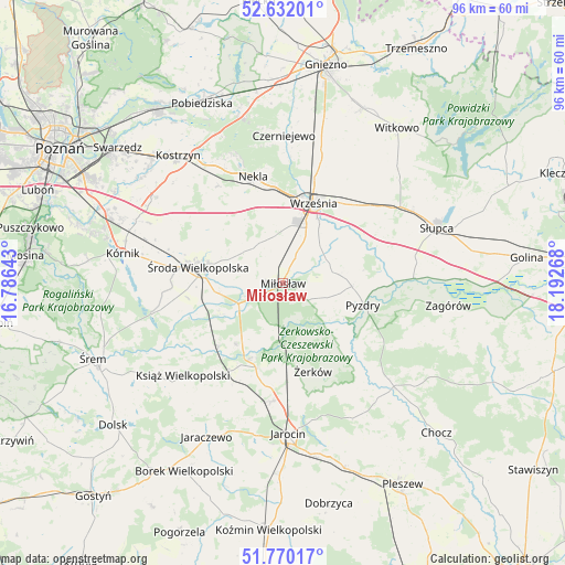
Miłosław GPS coordinates[2]
52° 12' 11.448" North, 17° 29' 22.38" East
| Map corner | latitude | longitude |
|---|---|---|
| Upper-left | 52.63201°, | 16.78643° |
| Center: | 52.20318°, | 17.48955° |
| Lower-right: | 51.77017°, | 18.19268° |
| Map W x H: | 95.8×95.8 km | = 59.5×59.5mi |
| max Lat: | 54.83135° ⇑29.8% North |
| Miłosław: | 52.20318° |
| min Lat: | ⇓70.2% South 49.21328° |
| min Long | Miłosław | max Long |
| 14.20249° | 17.48955° | 24.03723° |
| W 20%⇐ | ⇒80% E |
Elevation
Elevation of Miłosław is 85 m = 279 ft, and this is 106.4 m = 349 ft below average elevation for this country.
| Max E: |
974 m = 3196 ft | 86.8% |
| Avg. | 191.4 m = 628 ft | |
| Miłosław | 85 m = 279 ft | |
Min E: |
-3 m = -10 ft | 13.2% |
See also: Poland elevation on elevation.city.
Geographical zone
Miłosław is located in North temperate zone (between Tropic of Cancer and the Arctic Circle). Distance of this North polar circle is 1596.7 km =992.1 mi to North.| Distance of | km | miles | from Miłosław |
|---|---|---|---|
| North Pole | 4202.6 | 2611.4 | to North |
| Arctic Circle | 1596.7 | 992.1 | to North |
| Tropic Cancer | 3198.5 | 1987.5 | to South |
| Equator | 5804.4 | 3606.7 | to South |


Nearby cities:
15 places around Miłosław: (largest is in red/bold)
• Dominowo
13.3 km =8.3 mi,  317°
317°
• Grabowo Królewskie
9.9 km =6.2 mi,  64°
64°
• Kołaczkowo
9.3 km =5.8 mi,  80°
80°
• Krzykosy
13 km =8.1 mi,  217°
217°
• Lisewo
19.3 km =12 mi,  133°
133°
• Nekla
18.7 km =11.6 mi,  343°
343°
• Nowe Miasto nad Wartą
13.7 km =8.5 mi,  203°
203°
• Pyzdry
14.1 km =8.8 mi,  104°
104°
• Sokolniki
15.8 km =9.8 mi,  69°
69°
• Solec
15.3 km =9.5 mi,  225°
225°
• Słupia Wiełka
18.5 km =11.5 mi,  275°
275°
• Tomice
22.8 km =14.2 mi, 131°
• Września
14.5 km =9 mi,  20°
20°
• Środa Wielkopolska
14.8 km =9.2 mi, 280°
• Żerków
15.8 km =9.8 mi,  161°
161°
Sources, notices
• [Note1] Compared only with cities in Poland existing in our database
• [Src1] Map data: © OpenStreetMap contributors (CC-BY-SA)
• [Src2] Other city data from geonames.org with taken over terms of usage.
• [Src3] Geographical zone / Annual Mean Temperature by Robert A. Rohde @ Wikipedia
