Sopot geodata
Sopot (Pomerania) is a populated place; located in Poland in Europe/Warsaw (GMT+2) time zone. With population of 40,142 people, there are 125 cities with bigger population in this country. Compared to other cities in Poland, 98.5% of cities are located further ↓South; 67.3% of cities are located further →East and 97.2% of cities have higher elevation than Sopot. Note1


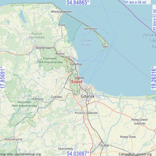
Sopot GPS coordinates[2]
54° 26' 30.48" North, 18° 33' 36.108" East
| Map corner | latitude | longitude |
|---|---|---|
| Upper-left | 54.84865°, | 17.85691° |
| Center: | 54.4418°, | 18.56003° |
| Lower-right: | 54.03087°, | 19.26316° |
| Map W x H: | 90.9×90.9 km | = 56.5×56.5mi |
| max Lat: | 54.83135° ⇑1.5% North |
| Sopot: | 54.4418° |
| min Lat: | ⇓98.5% South 49.21328° |
| min Long | Sopot | max Long |
| 14.20249° | 18.56003° | 24.03723° |
| W 32.7%⇐ | ⇒67.3% E |
Elevation
Elevation of Sopot is 20 m = 66 ft, and this is 171.4 m = 562 ft below average elevation for this country.
| Max E: |
974 m = 3196 ft | 97.2% |
| Avg. | 191.4 m = 628 ft | |
| Sopot | 20 m = 66 ft | |
Min E: |
-3 m = -10 ft | 2.8% |
See also: Sopot elevation on elevation.city.
Geographical zone
Sopot is located in North temperate zone (between Tropic of Cancer and the Arctic Circle). Distance of this North polar circle is 1347.8 km =837.5 mi to North.| Distance of | km | miles | from Sopot |
|---|---|---|---|
| North Pole | 3953.7 | 2456.7 | to North |
| Arctic Circle | 1347.8 | 837.5 | to North |
| Tropic Cancer | 3447.4 | 2142.1 | to South |
| Equator | 6053.4 | 3761.4 | to South |


Nearby cities:
15 places around Sopot: (largest is in red/bold)
• Banino
11.4 km =7.1 mi,  240°
240°
• Bojano
11.8 km =7.3 mi,  286°
286°
• Borkowo Łostowickie
16 km =9.9 mi,  171°
171°
• Chwaszczyno
9.1 km =5.7 mi,  271°
271°
• Gdańsk
11.4 km =7.1 mi,  150°
150°
• Gdynia
8.8 km =5.5 mi,  348°
348°
• Koleczkowo
14.8 km =9.2 mi, 289°
• Kosakowo
17.1 km =10.6 mi,  343°
343°
• Kowale
14.7 km =9.1 mi,  179°
179°
• Pierwoszyno
17.7 km =11 mi, 347°
• Pogórze
14.5 km =9 mi, 339°
• Przejazdowo
17.5 km =10.9 mi,  136°
136°
• Pępowo
13.6 km =8.5 mi, 235°
• Wielki Kack
5.5 km =3.4 mi,  301°
301°
• Żukowo
16.8 km =10.4 mi,  228°
228°
Sources, notices
• [Note1] Compared only with cities in Poland existing in our database
• [Src1] Map data: © OpenStreetMap contributors (CC-BY-SA)
• [Src2] Other city data from geonames.org with taken over terms of usage.
• [Src3] Geographical zone / Annual Mean Temperature by Robert A. Rohde @ Wikipedia
