Gdynia geodata
Gdynia (Pomerania) is a populated place; located in Poland in Europe/Warsaw (GMT+2) time zone. With population of 253,730 people, there are 11 cities with bigger population in this country. Compared to other cities in Poland, 98.8% of cities are located further ↓South; 67.5% of cities are located further →East and 98.1% of cities have higher elevation than Gdynia. Note1


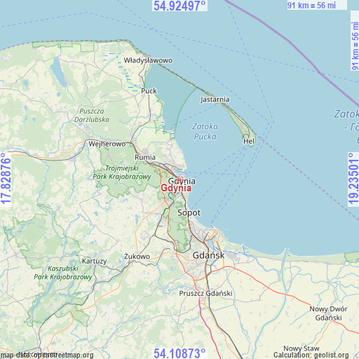
Gdynia GPS coordinates[2]
54° 31' 8.004" North, 18° 31' 54.768" East
| Map corner | latitude | longitude |
|---|---|---|
| Upper-left | 54.92497°, | 17.82876° |
| Center: | 54.51889°, | 18.53188° |
| Lower-right: | 54.10873°, | 19.23501° |
| Map W x H: | 90.8×90.8 km | = 56.4×56.4mi |
| max Lat: | 54.83135° ⇑1.2% North |
| Gdynia: | 54.51889° |
| min Lat: | ⇓98.8% South 49.21328° |
| min Long | Gdynia | max Long |
| 14.20249° | 18.53188° | 24.03723° |
| W 32.5%⇐ | ⇒67.5% E |
Elevation
Elevation of Gdynia is 14 m = 46 ft, and this is 177.4 m = 582 ft below average elevation for this country.
| Max E: |
974 m = 3196 ft | 98.1% |
| Avg. | 191.4 m = 628 ft | |
| Gdynia | 14 m = 46 ft | |
Min E: |
-3 m = -10 ft | 1.9% |
See also: Gdynia elevation on elevation.city.
Geographical zone
Gdynia is located in North temperate zone (between Tropic of Cancer and the Arctic Circle). Distance of this North polar circle is 1339.2 km =832.1 mi to North.| Distance of | km | miles | from Gdynia |
|---|---|---|---|
| North Pole | 3945.1 | 2451.4 | to North |
| Arctic Circle | 1339.2 | 832.1 | to North |
| Tropic Cancer | 3456 | 2147.5 | to South |
| Equator | 6061.9 | 3766.7 | to South |


Nearby cities:
15 places around Gdynia: (largest is in red/bold)
• Banino
16.3 km =10.1 mi,  209°
209°
• Bojano
10.9 km =6.8 mi,  240°
240°
• Chwaszczyno
11.1 km =6.9 mi,  221°
221°
• Dębogórze
9.3 km =5.8 mi,  329°
329°
• Koleczkowo
12.7 km =7.9 mi,  253°
253°
• Kosakowo
8.4 km =5.2 mi,  338°
338°
• Mosty
10.6 km =6.6 mi,  347°
347°
• Mrzezino
16.4 km =10.2 mi, 336°
• Pierwoszyno
8.9 km =5.5 mi, 346°
• Pogórze
6 km =3.7 mi, 327°
• Reda
15.3 km =9.5 mi,  308°
308°
• Rewa
12.8 km =8 mi, 353°
• Rumia
10.9 km =6.8 mi,  301°
301°
• Sopot
8.8 km =5.5 mi,  168°
168°
• Wielki Kack
6.4 km =4 mi, 206°
Sources, notices
• [Note1] Compared only with cities in Poland existing in our database
• [Src1] Map data: © OpenStreetMap contributors (CC-BY-SA)
• [Src2] Other city data from geonames.org with taken over terms of usage.
• [Src3] Geographical zone / Annual Mean Temperature by Robert A. Rohde @ Wikipedia
