Wielki Kack geodata
Wielki Kack (Pomerania) is a populated place; located in Poland in Europe/Warsaw (GMT+2) time zone. With population of 10,012 people, there are 443 cities with bigger population in this country. Compared to other cities in Poland, 98.6% of cities are located further ↓South; 68.3% of cities are located further →East and 64.7% of cities have higher elevation than Wielki Kack. Note1


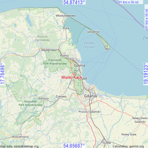
Wielki Kack GPS coordinates[2]
54° 28' 3.144" North, 18° 29' 17.16" East
| Map corner | latitude | longitude |
|---|---|---|
| Upper-left | 54.87413°, | 17.78498° |
| Center: | 54.46754°, | 18.4881° |
| Lower-right: | 54.05687°, | 19.19123° |
| Map W x H: | 90.9×90.9 km | = 56.5×56.5mi |
| max Lat: | 54.83135° ⇑1.4% North |
| Wielki Kack: | 54.46754° |
| min Lat: | ⇓98.6% South 49.21328° |
| min Long | Wielki Kack | max Long |
| 14.20249° | 18.4881° | 24.03723° |
| W 31.7%⇐ | ⇒68.3% E |
Elevation
Elevation of Wielki Kack is 134 m = 440 ft, and this is 57.4 m = 188 ft below average elevation for this country.
| Max E: |
974 m = 3196 ft | 64.7% |
| Avg. | 191.4 m = 628 ft | |
| Wielki Kack | 134 m = 440 ft | |
Min E: |
-3 m = -10 ft | 35.3% |
See also: Poland elevation on elevation.city.
Geographical zone
Wielki Kack is located in North temperate zone (between Tropic of Cancer and the Arctic Circle). Distance of this North polar circle is 1345 km =835.7 mi to North.| Distance of | km | miles | from Wielki Kack |
|---|---|---|---|
| North Pole | 3950.8 | 2454.9 | to North |
| Arctic Circle | 1345 | 835.7 | to North |
| Tropic Cancer | 3450.3 | 2143.9 | to South |
| Equator | 6056.2 | 3763.1 | to South |


Nearby cities:
15 places around Wielki Kack: (largest is in red/bold)
• Banino
9.9 km =6.2 mi,  212°
212°
• Bojano
6.7 km =4.2 mi,  273°
273°
• Chwaszczyno
5.2 km =3.2 mi,  239°
239°
• Dębogórze
13.8 km =8.6 mi,  352°
352°
• Gdynia
6.4 km =4 mi,  26°
26°
• Koleczkowo
9.6 km =6 mi,  282°
282°
• Kosakowo
13.5 km =8.4 mi,  359°
359°
• Mosty
16.1 km =10 mi,  1°
1°
• Pierwoszyno
14.4 km =8.9 mi, 3°
• Pogórze
10.8 km =6.7 mi, 357°
• Przodkowo
16.2 km =10.1 mi,  233°
233°
• Pępowo
12.5 km =7.8 mi, 211°
• Rumia
13.2 km =8.2 mi,  330°
330°
• Sopot
5.5 km =3.4 mi,  121°
121°
• Żukowo
16.1 km =10 mi, 209°
Sources, notices
• [Note1] Compared only with cities in Poland existing in our database
• [Src1] Map data: © OpenStreetMap contributors (CC-BY-SA)
• [Src2] Other city data from geonames.org with taken over terms of usage.
• [Src3] Geographical zone / Annual Mean Temperature by Robert A. Rohde @ Wikipedia
