Bojano geodata
Bojano (Pomerania) is a populated place; located in Poland in Europe/Warsaw (GMT+2) time zone. With population of 2,100 people, there are 1411 cities with bigger population in this country. Compared to other cities in Poland, 98.7% of cities are located further ↓South; 70.1% of cities are located further →East and 54.2% of cities have higher elevation than Bojano. Note1


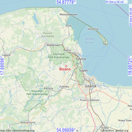
Bojano GPS coordinates[2]
54° 28' 16.428" North, 18° 23' 2.688" East
| Map corner | latitude | longitude |
|---|---|---|
| Upper-left | 54.87779°, | 17.68096° |
| Center: | 54.47123°, | 18.38408° |
| Lower-right: | 54.06059°, | 19.08721° |
| Map W x H: | 90.9×90.9 km | = 56.5×56.5mi |
| max Lat: | 54.83135° ⇑1.3% North |
| Bojano: | 54.47123° |
| min Lat: | ⇓98.7% South 49.21328° |
| min Long | Bojano | max Long |
| 14.20249° | 18.38408° | 24.03723° |
| W 29.9%⇐ | ⇒70.1% E |
Elevation
Elevation of Bojano is 161 m = 528 ft, and this is 30.4 m = 100 ft below average elevation for this country.
| Max E: |
974 m = 3196 ft | 54.2% |
| Avg. | 191.4 m = 628 ft | |
| Bojano | 161 m = 528 ft | |
Min E: |
-3 m = -10 ft | 45.8% |
See also: Poland elevation on elevation.city.
Geographical zone
Bojano is located in North temperate zone (between Tropic of Cancer and the Arctic Circle). Distance of this North polar circle is 1344.5 km =835.4 mi to North.| Distance of | km | miles | from Bojano |
|---|---|---|---|
| North Pole | 3950.4 | 2454.7 | to North |
| Arctic Circle | 1344.5 | 835.4 | to North |
| Tropic Cancer | 3450.7 | 2144.2 | to South |
| Equator | 6056.6 | 3763.4 | to South |


Nearby cities:
15 places around Bojano: (largest is in red/bold)
• Banino
8.9 km =5.5 mi,  170°
170°
• Chwaszczyno
3.8 km =2.4 mi,  143°
143°
• Dębogórze
14.1 km =8.8 mi,  19°
19°
• Gdynia
10.9 km =6.8 mi,  60°
60°
• Koleczkowo
3.1 km =1.9 mi,  302°
302°
• Kosakowo
14.6 km =9.1 mi,  26°
26°
• Pogórze
12.1 km =7.5 mi, 31°
• Przodkowo
11.9 km =7.4 mi,  211°
211°
• Pępowo
11.1 km =6.9 mi,  179°
179°
• Reda
15.1 km =9.4 mi,  350°
350°
• Rumia
11.1 km =6.9 mi,  1°
1°
• Sopot
11.8 km =7.3 mi,  106°
106°
• Szemud
10.6 km =6.6 mi,  279°
279°
• Wielki Kack
6.7 km =4.2 mi,  93°
93°
• Żukowo
14.4 km =8.9 mi, 184°
Sources, notices
• [Note1] Compared only with cities in Poland existing in our database
• [Src1] Map data: © OpenStreetMap contributors (CC-BY-SA)
• [Src2] Other city data from geonames.org with taken over terms of usage.
• [Src3] Geographical zone / Annual Mean Temperature by Robert A. Rohde @ Wikipedia
