Słubice geodata
Słubice (Mazovia) is a seat of a third-order administrative division; located in Poland in Europe/Warsaw (GMT+2) time zone. With population of 2,110 people, there are 1409 cities with bigger population in this country. Compared to other cities in Poland, 74.1% of cities are located further ↓South; 57.4% of cities are located further ←West and 91.8% of cities have higher elevation than Słubice. Note1


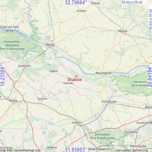
Słubice GPS coordinates[2]
52° 22' 9.912" North, 19° 56' 19.716" East
| Map corner | latitude | longitude |
|---|---|---|
| Upper-left | 52.79664°, | 19.23569° |
| Center: | 52.36942°, | 19.93881° |
| Lower-right: | 51.93803°, | 20.64194° |
| Map W x H: | 95.5×95.5 km | = 59.3×59.3mi |
| max Lat: | 54.83135° ⇑25.9% North |
| Słubice: | 52.36942° |
| min Lat: | ⇓74.1% South 49.21328° |
| min Long | Słubice | max Long |
| 14.20249° | 19.93881° | 24.03723° |
| W 57.4%⇐ | ⇒42.6% E |
Elevation
Elevation of Słubice is 66 m = 217 ft, and this is 125.4 m = 411 ft below average elevation for this country.
| Max E: |
974 m = 3196 ft | 91.8% |
| Avg. | 191.4 m = 628 ft | |
| Słubice | 66 m = 217 ft | |
Min E: |
-3 m = -10 ft | 8.2% |
See also: Poland elevation on elevation.city.
Geographical zone
Słubice is located in North temperate zone (between Tropic of Cancer and the Arctic Circle). Distance of this North polar circle is 1578.2 km =980.6 mi to North.| Distance of | km | miles | from Słubice |
|---|---|---|---|
| North Pole | 4184.1 | 2599.9 | to North |
| Arctic Circle | 1578.2 | 980.6 | to North |
| Tropic Cancer | 3217 | 1999 | to South |
| Equator | 5822.9 | 3618.2 | to South |


Nearby cities:
15 places around Słubice: (largest is in red/bold)
• Bodzanów
15.8 km =9.8 mi,  22°
22°
• Chąśno
19.4 km =12.1 mi,  179°
179°
• Gąbin
14.2 km =8.8 mi,  283°
283°
• Iłów
6.9 km =4.3 mi,  118°
118°
• Kiernozia
12.1 km =7.5 mi,  202°
202°
• Kocierzew Południowy
17.8 km =11.1 mi,  162°
162°
• Mała Wieś
14.8 km =9.2 mi,  48°
48°
• Młodzieszyn
19.4 km =12.1 mi,  113°
113°
• Pacyna
17.2 km =10.7 mi,  244°
244°
• Rybno
18 km =11.2 mi,  141°
141°
• Sanniki
6.5 km =4 mi,  228°
228°
• Stary Barcik
7.2 km =4.5 mi, 278°
• Słupno
16.7 km =10.4 mi,  335°
335°
• Wyszogród
17.3 km =10.7 mi,  82°
82°
• Łaziska
4.2 km =2.6 mi, 280°
Sources, notices
• [Note1] Compared only with cities in Poland existing in our database
• [Src1] Map data: © OpenStreetMap contributors (CC-BY-SA)
• [Src2] Other city data from geonames.org with taken over terms of usage.
• [Src3] Geographical zone / Annual Mean Temperature by Robert A. Rohde @ Wikipedia
