Iłów geodata
Iłów (Mazovia) is a seat of a third-order administrative division; located in Poland in Europe/Warsaw (GMT+2) time zone. With population of 690 people, there are 3089 cities with bigger population in this country. Compared to other cities in Poland, 73.4% of cities are located further ↓South; 58.7% of cities are located further ←West and 90.2% of cities have higher elevation than Iłów. Note1


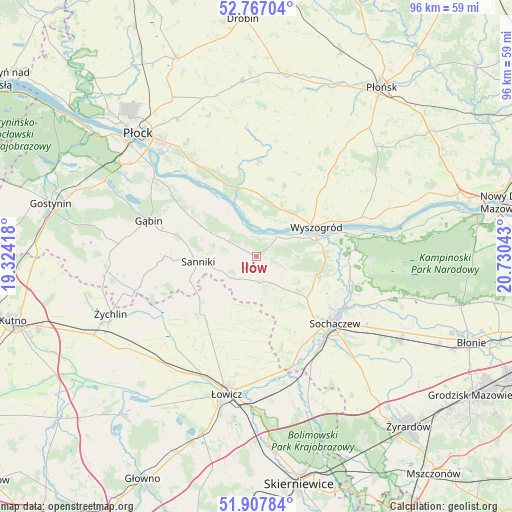
Iłów GPS coordinates[2]
52° 20' 22.308" North, 20° 1' 38.28" East
| Map corner | latitude | longitude |
|---|---|---|
| Upper-left | 52.76704°, | 19.32418° |
| Center: | 52.33953°, | 20.0273° |
| Lower-right: | 51.90784°, | 20.73043° |
| Map W x H: | 95.5×95.5 km | = 59.3×59.3mi |
| max Lat: | 54.83135° ⇑26.6% North |
| Iłów: | 52.33953° |
| min Lat: | ⇓73.4% South 49.21328° |
| min Long | Iłów | max Long |
| 14.20249° | 20.0273° | 24.03723° |
| W 58.7%⇐ | ⇒41.3% E |
Elevation
Elevation of Iłów is 75 m = 246 ft, and this is 116.4 m = 382 ft below average elevation for this country.
| Max E: |
974 m = 3196 ft | 90.2% |
| Avg. | 191.4 m = 628 ft | |
| Iłów | 75 m = 246 ft | |
Min E: |
-3 m = -10 ft | 9.8% |
See also: Poland elevation on elevation.city.
Geographical zone
Iłów is located in North temperate zone (between Tropic of Cancer and the Arctic Circle). Distance of this North polar circle is 1581.6 km =982.8 mi to North.| Distance of | km | miles | from Iłów |
|---|---|---|---|
| North Pole | 4187.5 | 2602 | to North |
| Arctic Circle | 1581.6 | 982.8 | to North |
| Tropic Cancer | 3213.7 | 1996.9 | to South |
| Equator | 5819.6 | 3616.1 | to South |


Nearby cities:
15 places around Iłów: (largest is in red/bold)
• Bodzanów
17.8 km =11.1 mi,  0°
0°
• Brochów
16.1 km =10 mi,  97°
97°
• Chąśno
17 km =10.6 mi,  199°
199°
• Kiernozia
13.2 km =8.2 mi,  233°
233°
• Kocierzew Południowy
13.6 km =8.5 mi,  182°
182°
• Kozłów Biskupi
19.9 km =12.4 mi,  145°
145°
• Mała Wieś
14.1 km =8.8 mi,  21°
21°
• Młodzieszyn
12.6 km =7.8 mi,  110°
110°
• Rybno
11.9 km =7.4 mi, 154°
• Sanniki
10.9 km =6.8 mi,  264°
264°
• Sochaczew
18.9 km =11.7 mi,  130°
130°
• Stary Barcik
13.8 km =8.6 mi,  288°
288°
• Słubice
6.9 km =4.3 mi,  298°
298°
• Wyszogród
12.4 km =7.7 mi,  63°
63°
• Łaziska
10.9 km =6.8 mi, 291°
Sources, notices
• [Note1] Compared only with cities in Poland existing in our database
• [Src1] Map data: © OpenStreetMap contributors (CC-BY-SA)
• [Src2] Other city data from geonames.org with taken over terms of usage.
• [Src3] Geographical zone / Annual Mean Temperature by Robert A. Rohde @ Wikipedia
