Mała Wieś geodata
Mała Wieś (Mazovia) is a seat of a third-order administrative division; located in Poland in Europe/Warsaw (GMT+2) time zone. With population of 1,361 people, there are 2013 cities with bigger population in this country. Compared to other cities in Poland, 75.7% of cities are located further ↓South; 60% of cities are located further ←West and 72.6% of cities have higher elevation than Mała Wieś. Note1


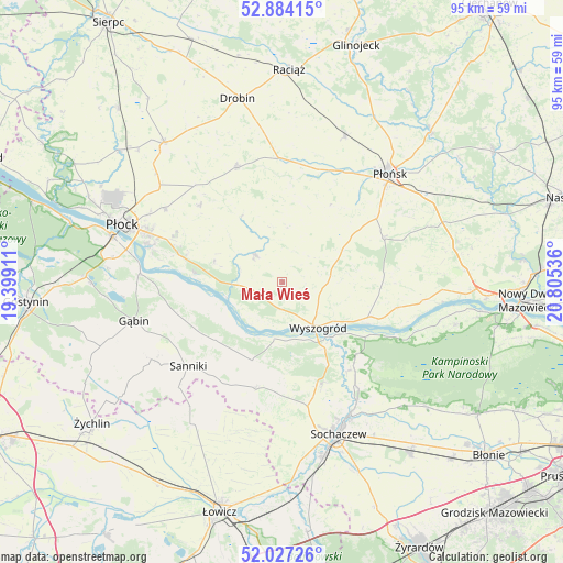
Mała Wieś GPS coordinates[2]
52° 27' 28.044" North, 20° 6' 8.028" East
| Map corner | latitude | longitude |
|---|---|---|
| Upper-left | 52.88415°, | 19.39911° |
| Center: | 52.45779°, | 20.10223° |
| Lower-right: | 52.02726°, | 20.80536° |
| Map W x H: | 95.3×95.3 km | = 59.2×59.2mi |
| max Lat: | 54.83135° ⇑24.3% North |
| Mała Wieś: | 52.45779° |
| min Lat: | ⇓75.7% South 49.21328° |
| min Long | Mała Wieś | max Long |
| 14.20249° | 20.10223° | 24.03723° |
| W 60%⇐ | ⇒40% E |
Elevation
Elevation of Mała Wieś is 116 m = 381 ft, and this is 75.4 m = 247 ft below average elevation for this country.
| Max E: |
974 m = 3196 ft | 72.6% |
| Avg. | 191.4 m = 628 ft | |
| Mała Wieś | 116 m = 381 ft | |
Min E: |
-3 m = -10 ft | 27.4% |
See also: Poland elevation on elevation.city.
Geographical zone
Mała Wieś is located in North temperate zone (between Tropic of Cancer and the Arctic Circle). Distance of this North polar circle is 1568.4 km =974.6 mi to North.| Distance of | km | miles | from Mała Wieś |
|---|---|---|---|
| North Pole | 4174.3 | 2593.8 | to North |
| Arctic Circle | 1568.4 | 974.6 | to North |
| Tropic Cancer | 3226.8 | 2005 | to South |
| Equator | 5832.8 | 3624.3 | to South |


Nearby cities:
15 places around Mała Wieś: (largest is in red/bold)
• Bodzanów
6.8 km =4.2 mi,  313°
313°
• Brochów
18.8 km =11.7 mi,  144°
144°
• Bulkowo
9.3 km =5.8 mi,  6°
6°
• Czerwińsk Nad Wisłą
15.5 km =9.6 mi,  115°
115°
• Dzierzążnia
20.9 km =13 mi,  25°
25°
• Iłów
14.1 km =8.8 mi,  201°
201°
• Młodzieszyn
18.8 km =11.7 mi,  159°
159°
• Naruszewo
18.5 km =11.5 mi,  65°
65°
• Radzanowo
19.2 km =11.9 mi, 311°
• Staroźreby
21 km =13 mi,  337°
337°
• Stary Barcik
20.1 km =12.5 mi,  244°
244°
• Słubice
14.8 km =9.2 mi,  228°
228°
• Słupno
18.7 km =11.6 mi,  286°
286°
• Wyszogród
9.6 km =6 mi, 141°
• Łaziska
17.7 km =11 mi, 239°
Sources, notices
• [Note1] Compared only with cities in Poland existing in our database
• [Src1] Map data: © OpenStreetMap contributors (CC-BY-SA)
• [Src2] Other city data from geonames.org with taken over terms of usage.
• [Src3] Geographical zone / Annual Mean Temperature by Robert A. Rohde @ Wikipedia
