Michałow geodata
Michałow (Opole Voivodeship) is a populated place; located in Poland in Europe/Warsaw (GMT+2) time zone. With population of 550 people, there are 3408 cities with bigger population in this country. Compared to other cities in Poland, 61.6% of cities are located further ↑North; 79.7% of cities are located further →East and 52.5% of cities have higher elevation than Michałow. Note1


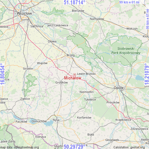
Michałow GPS coordinates[2]
50° 44' 39.588" North, 17° 30' 27.576" East
| Map corner | latitude | longitude |
|---|---|---|
| Upper-left | 51.18714°, | 16.80454° |
| Center: | 50.74433°, | 17.50766° |
| Lower-right: | 50.29729°, | 18.21079° |
| Map W x H: | 98.9×98.9 km | = 61.5×61.5mi |
| max Lat: | 54.83135° ⇑61.6% North |
| Michałow: | 50.74433° |
| min Lat: | ⇓38.4% South 49.21328° |
| min Long | Michałow | max Long |
| 14.20249° | 17.50766° | 24.03723° |
| W 20.3%⇐ | ⇒79.7% E |
Elevation
Elevation of Michałow is 165 m = 541 ft, and this is 26.4 m = 87 ft below average elevation for this country.
| Max E: |
974 m = 3196 ft | 52.5% |
| Avg. | 191.4 m = 628 ft | |
| Michałow | 165 m = 541 ft | |
Min E: |
-3 m = -10 ft | 47.5% |
See also: Poland elevation on elevation.city.
Geographical zone
Michałow is located in North temperate zone (between Tropic of Cancer and the Arctic Circle). Distance of this North polar circle is 1758.9 km =1092.9 mi to North.| Distance of | km | miles | from Michałow |
|---|---|---|---|
| North Pole | 4364.8 | 2712.2 | to North |
| Arctic Circle | 1758.9 | 1092.9 | to North |
| Tropic Cancer | 3036.3 | 1886.7 | to South |
| Equator | 5642.2 | 3505.9 | to South |


Nearby cities:
15 places around Michałow: (largest is in red/bold)
• Borkowice
14.6 km =9.1 mi,  91°
91°
• Brzeg
13.3 km =8.3 mi,  347°
347°
• Chróścina
16.7 km =10.4 mi,  215°
215°
• Dąbrowa
18.3 km =11.4 mi,  111°
111°
• Grodków
10.1 km =6.3 mi,  239°
239°
• Krzyżowice
7.7 km =4.8 mi,  336°
336°
• Lewin Brzeski
7.7 km =4.8 mi, 86°
• Niemodlin
13.8 km =8.6 mi,  145°
145°
• Olszanka
6 km =3.7 mi, 340°
• Pogorzela
4.9 km =3 mi, 348°
• Popielów
18.9 km =11.7 mi,  61°
61°
• Skarbimierz Osiedle
12.9 km =8 mi,  331°
331°
• Skorogoszcz
12.4 km =7.7 mi,  82°
82°
• Skoroszyce
18.7 km =11.6 mi,  208°
208°
• Łosiów
6.6 km =4.1 mi,  38°
38°
Sources, notices
• [Note1] Compared only with cities in Poland existing in our database
• [Src1] Map data: © OpenStreetMap contributors (CC-BY-SA)
• [Src2] Other city data from geonames.org with taken over terms of usage.
• [Src3] Geographical zone / Annual Mean Temperature by Robert A. Rohde @ Wikipedia
