Secemin geodata
Secemin (Świętokrzyskie) is a populated place; located in Poland in Europe/Warsaw (GMT+2) time zone. With population of 1,600 people, there are 1751 cities with bigger population in this country. Compared to other cities in Poland, 61% of cities are located further ↑North; 55.6% of cities are located further ←West and 73.8% of cities have lower elevation than Secemin. Note1


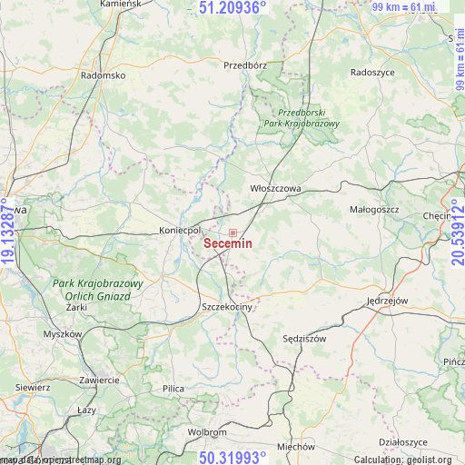
Secemin GPS coordinates[2]
50° 46' 0.336" North, 19° 50' 9.564" East
| Map corner | latitude | longitude |
|---|---|---|
| Upper-left | 51.20936°, | 19.13287° |
| Center: | 50.76676°, | 19.83599° |
| Lower-right: | 50.31993°, | 20.53912° |
| Map W x H: | 98.9×98.9 km | = 61.5×61.5mi |
| max Lat: | 54.83135° ⇑61% North |
| Secemin: | 50.76676° |
| min Lat: | ⇓39% South 49.21328° |
| min Long | Secemin | max Long |
| 14.20249° | 19.83599° | 24.03723° |
| W 55.6%⇐ | ⇒44.4% E |
Elevation
Elevation of Secemin is 242 m = 794 ft, and this is 50.6 m = 166 ft above average elevation for this country.
| Max E: |
974 m = 3196 ft | 26.2% |
| Secemin | 242 m 794 ft | |
| Avg. | 191.4 m = 628 ft | |
Min E: |
-3 m = -10 ft | 73.8% |
See also: Poland elevation on elevation.city.
Geographical zone
Secemin is located in North temperate zone (between Tropic of Cancer and the Arctic Circle). Distance of this North polar circle is 1756.4 km =1091.4 mi to North.| Distance of | km | miles | from Secemin |
|---|---|---|---|
| North Pole | 4362.3 | 2710.6 | to North |
| Arctic Circle | 1756.4 | 1091.4 | to North |
| Tropic Cancer | 3038.8 | 1888.2 | to South |
| Equator | 5644.7 | 3507.5 | to South |


Nearby cities:
15 places around Secemin: (largest is in red/bold)
• Drochlin
14.4 km =8.9 mi,  253°
253°
• Goleniowy
15.1 km =9.4 mi,  169°
169°
• Irządze
18.9 km =11.7 mi,  214°
214°
• Kluczewsko
18.8 km =11.7 mi,  17°
17°
• Koniecpol
10.4 km =6.5 mi,  274°
274°
• Lelów
17.5 km =10.9 mi,  237°
237°
• Moskorzew
15.1 km =9.4 mi,  152°
152°
• Nakło
14.5 km =9 mi, 212°
• Oksa
19.1 km =11.9 mi,  102°
102°
• Psary
4.1 km =2.5 mi,  191°
191°
• Radków
12.1 km =7.5 mi,  118°
118°
• Soborzyce
18.6 km =11.6 mi,  303°
303°
• Szczekociny
15.6 km =9.7 mi,  182°
182°
• Wola Wiśniowa
13 km =8.1 mi,  60°
60°
• Włoszczowa
13.2 km =8.2 mi,  43°
43°
Sources, notices
• [Note1] Compared only with cities in Poland existing in our database
• [Src1] Map data: © OpenStreetMap contributors (CC-BY-SA)
• [Src2] Other city data from geonames.org with taken over terms of usage.
• [Src3] Geographical zone / Annual Mean Temperature by Robert A. Rohde @ Wikipedia
