Wola Wiśniowa geodata
Wola Wiśniowa (Świętokrzyskie) is a populated place; located in Poland in Europe/Warsaw (GMT+2) time zone. With population of 752 people, there are 2950 cities with bigger population in this country. Compared to other cities in Poland, 59.6% of cities are located further ↑North; 58.3% of cities are located further ←West and 79.4% of cities have lower elevation than Wola Wiśniowa. Note1
Administrative division(s):
- Level 1: Świętokrzyskie
- Level 2: Powiat włoszczowski
- Level 3: Włoszczowa


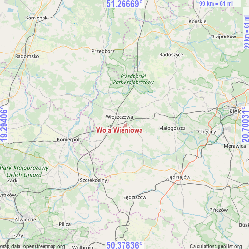
Wola Wiśniowa GPS coordinates[2]
50° 49' 28.704" North, 19° 59' 49.848" East
| Map corner | latitude | longitude |
|---|---|---|
| Upper-left | 51.26669°, | 19.29406° |
| Center: | 50.82464°, | 19.99718° |
| Lower-right: | 50.37836°, | 20.70031° |
| Map W x H: | 98.8×98.8 km | = 61.4×61.4mi |
| max Lat: | 54.83135° ⇑59.6% North |
| Wola Wiśniowa: | 50.82464° |
| min Lat: | ⇓40.4% South 49.21328° |
| min Long | Wola Wiśniowa | max Long |
| 14.20249° | 19.99718° | 24.03723° |
| W 58.3%⇐ | ⇒41.7% E |
Elevation
Elevation of Wola Wiśniowa is 263 m = 863 ft, and this is 71.6 m = 235 ft above average elevation for this country.
| Max E: |
974 m = 3196 ft | 20.6% |
| Wola Wiśniowa | 263 m 863 ft | |
| Avg. | 191.4 m = 628 ft | |
Min E: |
-3 m = -10 ft | 79.4% |
See also: Poland elevation on elevation.city.
Geographical zone
Wola Wiśniowa is located in North temperate zone (between Tropic of Cancer and the Arctic Circle). Distance of this North polar circle is 1750 km =1087.4 mi to North.| Distance of | km | miles | from Wola Wiśniowa |
|---|---|---|---|
| North Pole | 4355.9 | 2706.6 | to North |
| Arctic Circle | 1750 | 1087.4 | to North |
| Tropic Cancer | 3045.3 | 1892.3 | to South |
| Equator | 5651.2 | 3511.5 | to South |


Nearby cities:
15 places around Wola Wiśniowa: (largest is in red/bold)
• Goleniowy
22.9 km =14.2 mi,  201°
201°
• Kluczewsko
12.7 km =7.9 mi,  334°
334°
• Koniecpol
22.4 km =13.9 mi,  255°
255°
• Kozłów
11.5 km =7.1 mi,  88°
88°
• Krasocin
11.1 km =6.9 mi,  50°
50°
• Małogoszcz
18.8 km =11.7 mi, 94°
• Moskorzew
20.2 km =12.6 mi,  192°
192°
• Nagłowice
18 km =11.2 mi,  154°
154°
• Oksa
12.9 km =8 mi, 145°
• Psary
16.1 km =10 mi,  229°
229°
• Radków
12.3 km =7.6 mi,  183°
183°
• Secemin
13 km =8.1 mi,  240°
240°
• Słupia
23.3 km =14.5 mi,  25°
25°
• Włoszczowa
3.8 km =2.4 mi,  324°
324°
• Łopuszno
22.5 km =14 mi, 52°
Sources, notices
• [Note1] Compared only with cities in Poland existing in our database
• [Src1] Map data: © OpenStreetMap contributors (CC-BY-SA)
• [Src2] Other city data from geonames.org with taken over terms of usage.
• [Src3] Geographical zone / Annual Mean Temperature by Robert A. Rohde @ Wikipedia
