Radków geodata
Radków (Świętokrzyskie) is a populated place; located in Poland in Europe/Warsaw (GMT+2) time zone. With population of 600 people, there are 3270 cities with bigger population in this country. Compared to other cities in Poland, 62.4% of cities are located further ↑North; 58.2% of cities are located further ←West and 76% of cities have lower elevation than Radków. Note1


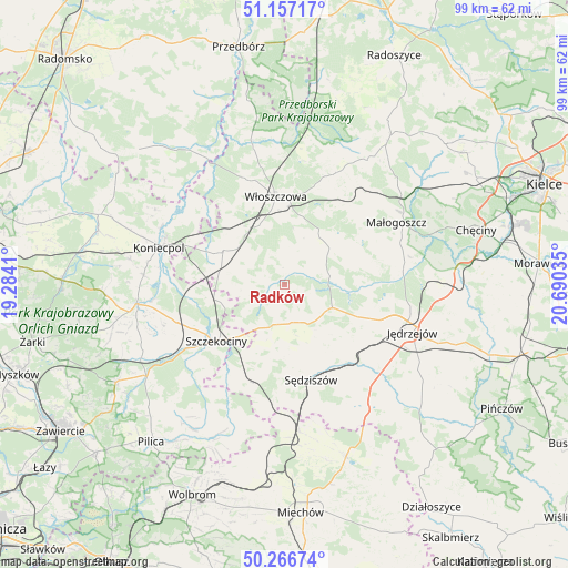
Radków GPS coordinates[2]
50° 42' 50.652" North, 19° 59' 13.992" East
| Map corner | latitude | longitude |
|---|---|---|
| Upper-left | 51.15717°, | 19.2841° |
| Center: | 50.71407°, | 19.98722° |
| Lower-right: | 50.26674°, | 20.69035° |
| Map W x H: | 99×99 km | = 61.5×61.5mi |
| max Lat: | 54.83135° ⇑62.4% North |
| Radków: | 50.71407° |
| min Lat: | ⇓37.6% South 49.21328° |
| min Long | Radków | max Long |
| 14.20249° | 19.98722° | 24.03723° |
| W 58.2%⇐ | ⇒41.8% E |
Elevation
Elevation of Radków is 250 m = 820 ft, and this is 58.6 m = 192 ft above average elevation for this country.
| Max E: |
974 m = 3196 ft | 24% |
| Radków | 250 m 820 ft | |
| Avg. | 191.4 m = 628 ft | |
Min E: |
-3 m = -10 ft | 76% |
See also: Poland elevation on elevation.city.
Geographical zone
Radków is located in North temperate zone (between Tropic of Cancer and the Arctic Circle). Distance of this North polar circle is 1762.3 km =1095 mi to North.| Distance of | km | miles | from Radków |
|---|---|---|---|
| North Pole | 4368.2 | 2714.3 | to North |
| Arctic Circle | 1762.3 | 1095 | to North |
| Tropic Cancer | 3033 | 1884.6 | to South |
| Equator | 5638.9 | 3503.8 | to South |


Nearby cities:
15 places around Radków: (largest is in red/bold)
• Goleniowy
11.9 km =7.4 mi,  221°
221°
• Kozłów
17.5 km =10.9 mi,  44°
44°
• Moskorzew
8.3 km =5.2 mi,  205°
205°
• Nagłowice
9.3 km =5.8 mi,  115°
115°
• Nakło
19.5 km =12.1 mi,  250°
250°
• Oksa
8.2 km =5.1 mi,  78°
78°
• Potok Wielki
21.1 km =13.1 mi,  126°
126°
• Psary
11.6 km =7.2 mi,  278°
278°
• Rokitno
20.4 km =12.7 mi,  225°
225°
• Secemin
12.1 km =7.5 mi,  298°
298°
• Szczekociny
15 km =9.3 mi, 229°
• Sędziszów
17.2 km =10.7 mi,  163°
163°
• Słupia
12.6 km =7.8 mi,  184°
184°
• Wola Wiśniowa
12.3 km =7.6 mi,  3°
3°
• Włoszczowa
15.5 km =9.6 mi,  354°
354°
Sources, notices
• [Note1] Compared only with cities in Poland existing in our database
• [Src1] Map data: © OpenStreetMap contributors (CC-BY-SA)
• [Src2] Other city data from geonames.org with taken over terms of usage.
• [Src3] Geographical zone / Annual Mean Temperature by Robert A. Rohde @ Wikipedia
