Moskorzew geodata
Moskorzew (Świętokrzyskie) is a populated place; located in Poland in Europe/Warsaw (GMT+2) time zone. With population of 644 people, there are 3182 cities with bigger population in this country. Compared to other cities in Poland, 64% of cities are located further ↑North; 57.3% of cities are located further ←West and 81.4% of cities have lower elevation than Moskorzew. Note1


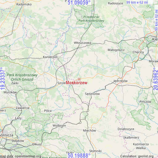
Moskorzew GPS coordinates[2]
50° 38' 48.66" North, 19° 56' 11.364" East
| Map corner | latitude | longitude |
|---|---|---|
| Upper-left | 51.09059°, | 19.23337° |
| Center: | 50.64685°, | 19.93649° |
| Lower-right: | 50.19888°, | 20.63962° |
| Map W x H: | 99.1×99.1 km | = 61.6×61.6mi |
| max Lat: | 54.83135° ⇑64% North |
| Moskorzew: | 50.64685° |
| min Lat: | ⇓36% South 49.21328° |
| min Long | Moskorzew | max Long |
| 14.20249° | 19.93649° | 24.03723° |
| W 57.3%⇐ | ⇒42.7% E |
Elevation
Elevation of Moskorzew is 273 m = 896 ft, and this is 81.6 m = 268 ft above average elevation for this country.
| Max E: |
974 m = 3196 ft | 18.6% |
| Moskorzew | 273 m 896 ft | |
| Avg. | 191.4 m = 628 ft | |
Min E: |
-3 m = -10 ft | 81.4% |
See also: Poland elevation on elevation.city.
Geographical zone
Moskorzew is located in North temperate zone (between Tropic of Cancer and the Arctic Circle). Distance of this North polar circle is 1769.8 km =1099.7 mi to North.| Distance of | km | miles | from Moskorzew |
|---|---|---|---|
| North Pole | 4375.7 | 2718.9 | to North |
| Arctic Circle | 1769.8 | 1099.7 | to North |
| Tropic Cancer | 3025.5 | 1880 | to South |
| Equator | 5631.4 | 3499.2 | to South |


Nearby cities:
15 places around Moskorzew: (largest is in red/bold)
• Goleniowy
4.5 km =2.8 mi,  250°
250°
• Irządze
17.9 km =11.1 mi,  262°
262°
• Kozłów
19.2 km =11.9 mi,  161°
161°
• Marcinowice
16.5 km =10.3 mi,  165°
165°
• Nagłowice
12.5 km =7.8 mi,  73°
73°
• Nakło
14.9 km =9.3 mi,  274°
274°
• Oksa
14.7 km =9.1 mi,  51°
51°
• Psary
12.2 km =7.6 mi,  319°
319°
• Radków
8.3 km =5.2 mi,  25°
25°
• Rokitno
12.9 km =8 mi,  237°
237°
• Secemin
15.1 km =9.4 mi,  332°
332°
• Szczekociny
8.2 km =5.1 mi, 254°
• Sędziszów
12.3 km =7.6 mi,  136°
136°
• Słupia
5.8 km =3.6 mi,  152°
152°
• Żarnowiec
19.4 km =12.1 mi,  195°
195°
Sources, notices
• [Note1] Compared only with cities in Poland existing in our database
• [Src1] Map data: © OpenStreetMap contributors (CC-BY-SA)
• [Src2] Other city data from geonames.org with taken over terms of usage.
• [Src3] Geographical zone / Annual Mean Temperature by Robert A. Rohde @ Wikipedia
