Włoszczowa geodata
Włoszczowa (Świętokrzyskie) is a seat of a third-order administrative division; located in Poland in Europe/Warsaw (GMT+2) time zone. With population of 10,661 people, there are 426 cities with bigger population in this country. Compared to other cities in Poland, 59% of cities are located further ↑North; 57.7% of cities are located further ←West and 72.8% of cities have lower elevation than Włoszczowa. Note1
Administrative division(s):
- Level 1: Świętokrzyskie
- Level 2: Powiat włoszczowski
- Level 3: Włoszczowa


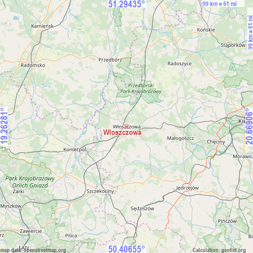
Włoszczowa GPS coordinates[2]
50° 51' 9.216" North, 19° 57' 57.348" East
| Map corner | latitude | longitude |
|---|---|---|
| Upper-left | 51.29435°, | 19.26281° |
| Center: | 50.85256°, | 19.96593° |
| Lower-right: | 50.40655°, | 20.66906° |
| Map W x H: | 98.7×98.7 km | = 61.3×61.3mi |
| max Lat: | 54.83135° ⇑59% North |
| Włoszczowa: | 50.85256° |
| min Lat: | ⇓41% South 49.21328° |
| min Long | Włoszczowa | max Long |
| 14.20249° | 19.96593° | 24.03723° |
| W 57.7%⇐ | ⇒42.3% E |
Elevation
Elevation of Włoszczowa is 239 m = 784 ft, and this is 47.6 m = 156 ft above average elevation for this country.
| Max E: |
974 m = 3196 ft | 27.2% |
| Włoszczowa | 239 m 784 ft | |
| Avg. | 191.4 m = 628 ft | |
Min E: |
-3 m = -10 ft | 72.8% |
See also: Poland elevation on elevation.city.
Geographical zone
Włoszczowa is located in North temperate zone (between Tropic of Cancer and the Arctic Circle). Distance of this North polar circle is 1746.9 km =1085.5 mi to North.| Distance of | km | miles | from Włoszczowa |
|---|---|---|---|
| North Pole | 4352.8 | 2704.7 | to North |
| Arctic Circle | 1746.9 | 1085.5 | to North |
| Tropic Cancer | 3048.4 | 1894.2 | to South |
| Equator | 5654.3 | 3513.4 | to South |


Nearby cities:
15 places around Włoszczowa: (largest is in red/bold)
• Kluczewsko
9 km =5.6 mi,  338°
338°
• Koniecpol
21.3 km =13.2 mi,  246°
246°
• Kozłów
14 km =8.7 mi,  101°
101°
• Krasocin
11.4 km =7.1 mi,  69°
69°
• Małogoszcz
21.4 km =13.3 mi, 102°
• Moskorzew
23 km =14.3 mi,  185°
185°
• Nagłowice
21.8 km =13.5 mi,  152°
152°
• Oksa
16.7 km =10.4 mi, 145°
• Psary
16.9 km =10.5 mi,  216°
216°
• Radków
15.5 km =9.6 mi,  174°
174°
• Secemin
13.2 km =8.2 mi, 223°
• Słupia
21.7 km =13.5 mi,  34°
34°
• Wielgomłyny
22.8 km =14.2 mi,  321°
321°
• Wola Wiśniowa
3.8 km =2.4 mi,  144°
144°
• Łopuszno
22.7 km =14.1 mi,  61°
61°
Sources, notices
• [Note1] Compared only with cities in Poland existing in our database
• [Src1] Map data: © OpenStreetMap contributors (CC-BY-SA)
• [Src2] Other city data from geonames.org with taken over terms of usage.
• [Src3] Geographical zone / Annual Mean Temperature by Robert A. Rohde @ Wikipedia
