Goleniowy geodata
Goleniowy (Silesia) is a populated place; located in Poland in Europe/Warsaw (GMT+2) time zone. With population of 789 people, there are 2884 cities with bigger population in this country. Compared to other cities in Poland, 64.4% of cities are located further ↑North; 56.4% of cities are located further ←West and 79.2% of cities have lower elevation than Goleniowy. Note1


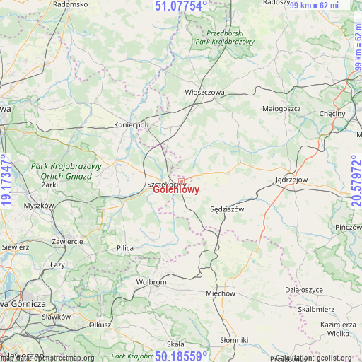
Goleniowy GPS coordinates[2]
50° 38' 1.248" North, 19° 52' 35.724" East
| Map corner | latitude | longitude |
|---|---|---|
| Upper-left | 51.07754°, | 19.17347° |
| Center: | 50.63368°, | 19.87659° |
| Lower-right: | 50.18559°, | 20.57972° |
| Map W x H: | 99.2×99.2 km | = 61.6×61.6mi |
| max Lat: | 54.83135° ⇑64.4% North |
| Goleniowy: | 50.63368° |
| min Lat: | ⇓35.6% South 49.21328° |
| min Long | Goleniowy | max Long |
| 14.20249° | 19.87659° | 24.03723° |
| W 56.4%⇐ | ⇒43.6% E |
Elevation
Elevation of Goleniowy is 262 m = 860 ft, and this is 70.6 m = 232 ft above average elevation for this country.
| Max E: |
974 m = 3196 ft | 20.8% |
| Goleniowy | 262 m 860 ft | |
| Avg. | 191.4 m = 628 ft | |
Min E: |
-3 m = -10 ft | 79.2% |
See also: Poland elevation on elevation.city.
Geographical zone
Goleniowy is located in North temperate zone (between Tropic of Cancer and the Arctic Circle). Distance of this North polar circle is 1771.2 km =1100.6 mi to North.| Distance of | km | miles | from Goleniowy |
|---|---|---|---|
| North Pole | 4377.1 | 2719.8 | to North |
| Arctic Circle | 1771.2 | 1100.6 | to North |
| Tropic Cancer | 3024 | 1879 | to South |
| Equator | 5629.9 | 3498.3 | to South |


Nearby cities:
15 places around Goleniowy: (largest is in red/bold)
• Irządze
13.5 km =8.4 mi,  266°
266°
• Lelów
18.5 km =11.5 mi,  287°
287°
• Marcinowice
16.8 km =10.4 mi,  149°
149°
• Moskorzew
4.5 km =2.8 mi,  70°
70°
• Nagłowice
17 km =10.6 mi, 72°
• Nakło
10.9 km =6.8 mi,  283°
283°
• Oksa
19 km =11.8 mi,  56°
56°
• Psary
11.4 km =7.1 mi,  340°
340°
• Radków
11.9 km =7.4 mi,  41°
41°
• Rokitno
8.6 km =5.3 mi,  230°
230°
• Secemin
15.1 km =9.4 mi,  349°
349°
• Szczekociny
3.7 km =2.3 mi,  257°
257°
• Sędziszów
14.7 km =9.1 mi,  120°
120°
• Słupia
7.8 km =4.8 mi, 117°
• Żarnowiec
17.2 km =10.7 mi,  183°
183°
Sources, notices
• [Note1] Compared only with cities in Poland existing in our database
• [Src1] Map data: © OpenStreetMap contributors (CC-BY-SA)
• [Src2] Other city data from geonames.org with taken over terms of usage.
• [Src3] Geographical zone / Annual Mean Temperature by Robert A. Rohde @ Wikipedia
