Oksa geodata
Oksa (Świętokrzyskie) is a seat of a third-order administrative division; located in Poland in Europe/Warsaw (GMT+2) time zone. With population of 890 people, there are 2695 cities with bigger population in this country. Compared to other cities in Poland, 62.1% of cities are located further ↑North; 60% of cities are located further ←West and 75.5% of cities have lower elevation than Oksa. Note1


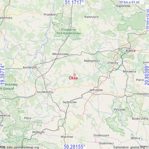
Oksa GPS coordinates[2]
50° 43' 43.464" North, 20° 6' 3.096" East
| Map corner | latitude | longitude |
|---|---|---|
| Upper-left | 51.1717°, | 19.39774° |
| Center: | 50.72874°, | 20.10086° |
| Lower-right: | 50.28155°, | 20.80399° |
| Map W x H: | 99×99 km | = 61.5×61.5mi |
| max Lat: | 54.83135° ⇑62.1% North |
| Oksa: | 50.72874° |
| min Lat: | ⇓37.9% South 49.21328° |
| min Long | Oksa | max Long |
| 14.20249° | 20.10086° | 24.03723° |
| W 60%⇐ | ⇒40% E |
Elevation
Elevation of Oksa is 248 m = 814 ft, and this is 56.6 m = 186 ft above average elevation for this country.
| Max E: |
974 m = 3196 ft | 24.5% |
| Oksa | 248 m 814 ft | |
| Avg. | 191.4 m = 628 ft | |
Min E: |
-3 m = -10 ft | 75.5% |
See also: Poland elevation on elevation.city.
Geographical zone
Oksa is located in North temperate zone (between Tropic of Cancer and the Arctic Circle). Distance of this North polar circle is 1760.7 km =1094 mi to North.| Distance of | km | miles | from Oksa |
|---|---|---|---|
| North Pole | 4366.6 | 2713.3 | to North |
| Arctic Circle | 1760.7 | 1094 | to North |
| Tropic Cancer | 3034.6 | 1885.6 | to South |
| Equator | 5640.5 | 3504.8 | to South |


Nearby cities:
15 places around Oksa: (largest is in red/bold)
• Goleniowy
19 km =11.8 mi,  236°
236°
• Jędrzejów
17.4 km =10.8 mi,  124°
124°
• Kozłów
11.7 km =7.3 mi,  21°
21°
• Krasocin
17.8 km =11.1 mi,  4°
4°
• Małogoszcz
14.8 km =9.2 mi,  51°
51°
• Moskorzew
14.7 km =9.1 mi,  231°
231°
• Nagłowice
5.6 km =3.5 mi,  175°
175°
• Potok Wielki
16.8 km =10.4 mi,  148°
148°
• Psary
19.5 km =12.1 mi,  270°
270°
• Radków
8.2 km =5.1 mi,  258°
258°
• Secemin
19.1 km =11.9 mi,  282°
282°
• Sędziszów
18.4 km =11.4 mi,  189°
189°
• Słupia
16.8 km =10.4 mi,  212°
212°
• Wola Wiśniowa
12.9 km =8 mi,  325°
325°
• Włoszczowa
16.7 km =10.4 mi, 325°
Sources, notices
• [Note1] Compared only with cities in Poland existing in our database
• [Src1] Map data: © OpenStreetMap contributors (CC-BY-SA)
• [Src2] Other city data from geonames.org with taken over terms of usage.
• [Src3] Geographical zone / Annual Mean Temperature by Robert A. Rohde @ Wikipedia
