Brodła geodata
Brodła (Lesser Poland) is a populated place; located in Poland in Europe/Warsaw (GMT+2) time zone. With population of 1,005 people, there are 2452 cities with bigger population in this country. Compared to other cities in Poland, 80.4% of cities are located further ↑North; 50.5% of cities are located further ←West and 81.9% of cities have lower elevation than Brodła. Note1


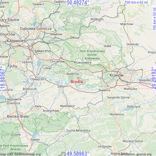
Brodła GPS coordinates[2]
50° 2' 35.916" North, 19° 35' 19.644" East
| Map corner | latitude | longitude |
|---|---|---|
| Upper-left | 50.49274°, | 18.88567° |
| Center: | 50.04331°, | 19.58879° |
| Lower-right: | 49.58963°, | 20.29192° |
| Map W x H: | 100.4×100.4 km | = 62.4×62.4mi |
| max Lat: | 54.83135° ⇑80.4% North |
| Brodła: | 50.04331° |
| min Lat: | ⇓19.6% South 49.21328° |
| min Long | Brodła | max Long |
| 14.20249° | 19.58879° | 24.03723° |
| W 50.5%⇐ | ⇒49.5% E |
Elevation
Elevation of Brodła is 275 m = 902 ft, and this is 83.6 m = 274 ft above average elevation for this country.
| Max E: |
974 m = 3196 ft | 18.1% |
| Brodła | 275 m 902 ft | |
| Avg. | 191.4 m = 628 ft | |
Min E: |
-3 m = -10 ft | 81.9% |
See also: Poland elevation on elevation.city.
Geographical zone
Brodła is located in North temperate zone (between Tropic of Cancer and the Arctic Circle). Distance of this North polar circle is 1836.9 km =1141.4 mi to North.| Distance of | km | miles | from Brodła |
|---|---|---|---|
| North Pole | 4442.8 | 2760.6 | to North |
| Arctic Circle | 1836.9 | 1141.4 | to North |
| Tropic Cancer | 2958.4 | 1838.3 | to South |
| Equator | 5564.3 | 3457.5 | to South |


Nearby cities:
15 places around Brodła: (largest is in red/bold)
• Alwernia
4 km =2.5 mi,  298°
298°
• Grojec
5.6 km =3.5 mi,  336°
336°
• Kamień
3.5 km =2.2 mi,  184°
184°
• Kwaczała
7.3 km =4.5 mi,  288°
288°
• Okleśna
4.3 km =2.7 mi,  251°
251°
• Przeginia Duchowna
5.3 km =3.3 mi,  118°
118°
• Przeginia Narodowa
6.2 km =3.9 mi,  126°
126°
• Regulice
6.2 km =3.9 mi,  315°
315°
• Rozkochów
7 km =4.3 mi,  271°
271°
• Rudno
6.3 km =3.9 mi,  352°
352°
• Rusocice
5.4 km =3.4 mi,  166°
166°
• Ryczów
7.5 km =4.7 mi,  201°
201°
• Sanka
5 km =3.1 mi,  55°
55°
• Zalas
4.7 km =2.9 mi,  29°
29°
• Łączany
6.6 km =4.1 mi,  186°
186°
Sources, notices
• [Note1] Compared only with cities in Poland existing in our database
• [Src1] Map data: © OpenStreetMap contributors (CC-BY-SA)
• [Src2] Other city data from geonames.org with taken over terms of usage.
• [Src3] Geographical zone / Annual Mean Temperature by Robert A. Rohde @ Wikipedia
