Radłow geodata
Radłow (Opole Voivodeship) is a populated place; located in Poland in Europe/Warsaw (GMT+2) time zone. With population of 627 people, there are 3215 cities with bigger population in this country. Compared to other cities in Poland, 56.7% of cities are located further ↑North; 67.5% of cities are located further →East and 78.1% of cities have lower elevation than Radłow. Note1


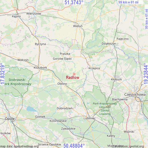
Radłow GPS coordinates[2]
50° 55' 59.808" North, 18° 32' 7.116" East
| Map corner | latitude | longitude |
|---|---|---|
| Upper-left | 51.3743°, | 17.83219° |
| Center: | 50.93328°, | 18.53531° |
| Lower-right: | 50.48804°, | 19.23844° |
| Map W x H: | 98.5×98.5 km | = 61.2×61.2mi |
| max Lat: | 54.83135° ⇑56.7% North |
| Radłow: | 50.93328° |
| min Lat: | ⇓43.3% South 49.21328° |
| min Long | Radłow | max Long |
| 14.20249° | 18.53531° | 24.03723° |
| W 32.5%⇐ | ⇒67.5% E |
Elevation
Elevation of Radłow is 258 m = 846 ft, and this is 66.6 m = 219 ft above average elevation for this country.
| Max E: |
974 m = 3196 ft | 21.9% |
| Radłow | 258 m 846 ft | |
| Avg. | 191.4 m = 628 ft | |
Min E: |
-3 m = -10 ft | 78.1% |
See also: Poland elevation on elevation.city.
Geographical zone
Radłow is located in North temperate zone (between Tropic of Cancer and the Arctic Circle). Distance of this North polar circle is 1737.9 km =1079.9 mi to North.| Distance of | km | miles | from Radłow |
|---|---|---|---|
| North Pole | 4343.8 | 2699.1 | to North |
| Arctic Circle | 1737.9 | 1079.9 | to North |
| Tropic Cancer | 3057.3 | 1899.7 | to South |
| Equator | 5663.2 | 3518.9 | to South |


Nearby cities:
15 places around Radłow: (largest is in red/bold)
• Dalachów
16.3 km =10.1 mi,  10°
10°
• Gorzów Śląski
13.2 km =8.2 mi,  323°
323°
• Kowale
16.8 km =10.4 mi,  345°
345°
• Krzepice
14.2 km =8.8 mi,  72°
72°
• Lasowice Małe
19.9 km =12.4 mi,  260°
260°
• Olesno
10.2 km =6.3 mi,  232°
232°
• Opatów
20.1 km =12.5 mi,  82°
82°
• Panki
16.1 km =10 mi,  110°
110°
• Praszka
14.6 km =9.1 mi,  336°
336°
• Przedmość
19.1 km =11.9 mi, 338°
• Przystajń
12.2 km =7.6 mi,  116°
116°
• Rudniki
12.5 km =7.8 mi,  20°
20°
• Sieraków Śląski
14.8 km =9.2 mi,  168°
168°
• Starokrzepice
8.4 km =5.2 mi, 78°
• Wojciechów
10.8 km =6.7 mi,  248°
248°
Sources, notices
• [Note1] Compared only with cities in Poland existing in our database
• [Src1] Map data: © OpenStreetMap contributors (CC-BY-SA)
• [Src2] Other city data from geonames.org with taken over terms of usage.
• [Src3] Geographical zone / Annual Mean Temperature by Robert A. Rohde @ Wikipedia
