Wińsko geodata
Wińsko (Lower Silesia) is a populated place; located in Poland in Europe/Warsaw (GMT+2) time zone. With population of 1,800 people, there are 1605 cities with bigger population in this country. Compared to other cities in Poland, 55.8% of cities are located further ↓South; 88.6% of cities are located further →East and 52.6% of cities have lower elevation than Wińsko. Note1


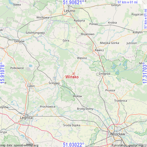
Wińsko GPS coordinates[2]
51° 28' 13.152" North, 16° 36' 50.04" East
| Map corner | latitude | longitude |
|---|---|---|
| Upper-left | 51.90621°, | 15.91078° |
| Center: | 51.47032°, | 16.6139° |
| Lower-right: | 51.03022°, | 17.31703° |
| Map W x H: | 97.4×97.4 km | = 60.5×60.5mi |
| max Lat: | 54.83135° ⇑44.2% North |
| Wińsko: | 51.47032° |
| min Lat: | ⇓55.8% South 49.21328° |
| min Long | Wińsko | max Long |
| 14.20249° | 16.6139° | 24.03723° |
| W 11.4%⇐ | ⇒88.6% E |
Elevation
Elevation of Wińsko is 179 m = 587 ft, and this is 12.4 m = 41 ft below average elevation for this country.
| Max E: |
974 m = 3196 ft | 47.4% |
| Avg. | 191.4 m = 628 ft | |
| Wińsko | 179 m = 587 ft | |
Min E: |
-3 m = -10 ft | 52.6% |
See also: Poland elevation on elevation.city.
Geographical zone
Wińsko is located in North temperate zone (between Tropic of Cancer and the Arctic Circle). Distance of this North polar circle is 1678.2 km =1042.8 mi to North.| Distance of | km | miles | from Wińsko |
|---|---|---|---|
| North Pole | 4284.1 | 2662 | to North |
| Arctic Circle | 1678.2 | 1042.8 | to North |
| Tropic Cancer | 3117 | 1936.8 | to South |
| Equator | 5723 | 3556.1 | to South |


Nearby cities:
15 places around Wińsko: (largest is in red/bold)
• Bojanowo
28 km =17.4 mi,  19°
19°
• Brzeg Dolny
22.9 km =14.2 mi,  163°
163°
• Dębno Polskie
22.4 km =13.9 mi,  55°
55°
• Góra
22.5 km =14 mi,  345°
345°
• Jemielno
7.7 km =4.8 mi,  320°
320°
• Lisowice
27.4 km =17 mi,  222°
222°
• Prochowice
27.9 km =17.3 mi, 218°
• Prusice
26.4 km =16.4 mi,  114°
114°
• Rawicz
22.9 km =14.2 mi,  47°
47°
• Rudna
24.6 km =15.3 mi,  280°
280°
• Szymanowo
24.4 km =15.2 mi, 52°
• Wołów
15 km =9.3 mi,  171°
171°
• Wąsosz
11.5 km =7.1 mi,  27°
27°
• Ścinawa
14.4 km =8.9 mi,  245°
245°
• Żmigród
20.2 km =12.6 mi,  91°
91°
Sources, notices
• [Note1] Compared only with cities in Poland existing in our database
• [Src1] Map data: © OpenStreetMap contributors (CC-BY-SA)
• [Src2] Other city data from geonames.org with taken over terms of usage.
• [Src3] Geographical zone / Annual Mean Temperature by Robert A. Rohde @ Wikipedia
