Rozprza geodata
Rozprza (Łódź Voivodeship) is a seat of a third-order administrative division; located in Poland in Europe/Warsaw (GMT+2) time zone. With population of 1,646 people, there are 1724 cities with bigger population in this country. Compared to other cities in Poland, 53.2% of cities are located further ↓South; 51.7% of cities are located further ←West and 58.3% of cities have lower elevation than Rozprza. Note1


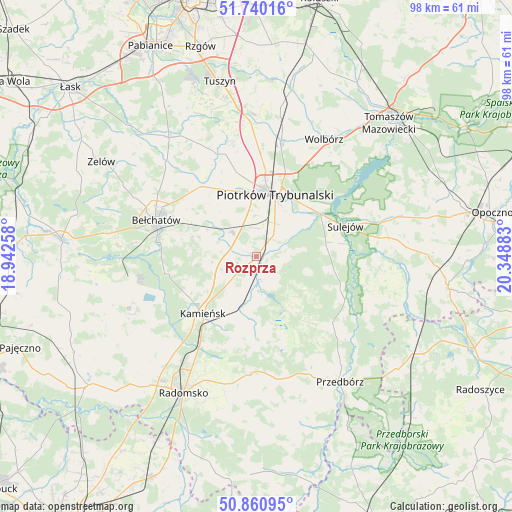
Rozprza GPS coordinates[2]
51° 18' 9.576" North, 19° 38' 44.52" East
| Map corner | latitude | longitude |
|---|---|---|
| Upper-left | 51.74016°, | 18.94258° |
| Center: | 51.30266°, | 19.6457° |
| Lower-right: | 50.86095°, | 20.34883° |
| Map W x H: | 97.8×97.8 km | = 60.8×60.8mi |
| max Lat: | 54.83135° ⇑46.8% North |
| Rozprza: | 51.30266° |
| min Lat: | ⇓53.2% South 49.21328° |
| min Long | Rozprza | max Long |
| 14.20249° | 19.6457° | 24.03723° |
| W 51.7%⇐ | ⇒48.3% E |
Elevation
Elevation of Rozprza is 194 m = 636 ft, and this is 2.6 m = 9 ft above average elevation for this country.
| Max E: |
974 m = 3196 ft | 41.7% |
| Rozprza | 194 m 636 ft | |
| Avg. | 191.4 m = 628 ft | |
Min E: |
-3 m = -10 ft | 58.3% |
See also: Poland elevation on elevation.city.
Geographical zone
Rozprza is located in North temperate zone (between Tropic of Cancer and the Arctic Circle). Distance of this North polar circle is 1696.9 km =1054.4 mi to North.| Distance of | km | miles | from Rozprza |
|---|---|---|---|
| North Pole | 4302.7 | 2673.6 | to North |
| Arctic Circle | 1696.9 | 1054.4 | to North |
| Tropic Cancer | 3098.4 | 1925.3 | to South |
| Equator | 5704.3 | 3544.5 | to South |


Nearby cities:
15 places around Rozprza: (largest is in red/bold)
• Aleksandrów
24.2 km =15 mi,  98°
98°
• Bełchatów
21.4 km =13.3 mi,  290°
290°
• Dobroszyce
24 km =14.9 mi,  222°
222°
• Gomunice
18.3 km =11.4 mi, 215°
• Gorzkowice
10.3 km =6.4 mi,  199°
199°
• Grabica
21.2 km =13.2 mi,  338°
338°
• Kamieńsk
15.2 km =9.4 mi, 222°
• Kodrąb
22.6 km =14 mi,  183°
183°
• Moszczenica
22.9 km =14.2 mi,  13°
13°
• Piotrków Trybunalski
12.1 km =7.5 mi,  19°
19°
• Ręczno
19.1 km =11.9 mi,  130°
130°
• Sulejów
17.6 km =10.9 mi,  70°
70°
• Wola Krzysztoporska
6.4 km =4 mi,  315°
315°
• Łęki Szlacheckie
16.6 km =10.3 mi,  140°
140°
• Łękińsko
22.9 km =14.2 mi,  245°
245°
Sources, notices
• [Note1] Compared only with cities in Poland existing in our database
• [Src1] Map data: © OpenStreetMap contributors (CC-BY-SA)
• [Src2] Other city data from geonames.org with taken over terms of usage.
• [Src3] Geographical zone / Annual Mean Temperature by Robert A. Rohde @ Wikipedia
