Kodrąb geodata
Kodrąb (Łódź Voivodeship) is a populated place; located in Poland in Europe/Warsaw (GMT+2) time zone. With population of 720 people, there are 3027 cities with bigger population in this country. Compared to other cities in Poland, 52.5% of cities are located further ↑North; 51.4% of cities are located further ←West and 72.4% of cities have lower elevation than Kodrąb. Note1
Administrative division(s):
- Level 1: Łódź Voivodeship
- Level 2: Powiat radomszczański
- Level 3: Kodrąb


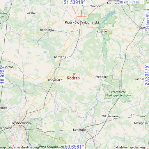
Kodrąb GPS coordinates[2]
51° 5' 59.1" North, 19° 37' 43.032" East
| Map corner | latitude | longitude |
|---|---|---|
| Upper-left | 51.53918°, | 18.9255° |
| Center: | 51.09975°, | 19.62862° |
| Lower-right: | 50.6561°, | 20.33175° |
| Map W x H: | 98.2×98.2 km | = 61×61mi |
| max Lat: | 54.83135° ⇑52.5% North |
| Kodrąb: | 51.09975° |
| min Lat: | ⇓47.5% South 49.21328° |
| min Long | Kodrąb | max Long |
| 14.20249° | 19.62862° | 24.03723° |
| W 51.4%⇐ | ⇒48.6% E |
Elevation
Elevation of Kodrąb is 237 m = 778 ft, and this is 45.6 m = 150 ft above average elevation for this country.
| Max E: |
974 m = 3196 ft | 27.6% |
| Kodrąb | 237 m 778 ft | |
| Avg. | 191.4 m = 628 ft | |
Min E: |
-3 m = -10 ft | 72.4% |
See also: Poland elevation on elevation.city.
Geographical zone
Kodrąb is located in North temperate zone (between Tropic of Cancer and the Arctic Circle). Distance of this North polar circle is 1719.4 km =1068.4 mi to North.| Distance of | km | miles | from Kodrąb |
|---|---|---|---|
| North Pole | 4325.3 | 2687.6 | to North |
| Arctic Circle | 1719.4 | 1068.4 | to North |
| Tropic Cancer | 3075.8 | 1911.2 | to South |
| Equator | 5681.8 | 3530.5 | to South |


Nearby cities:
15 places around Kodrąb: (largest is in red/bold)
• Dobroszyce
16 km =9.9 mi,  288°
288°
• Gidle
18.8 km =11.7 mi,  215°
215°
• Gomunice
12.2 km =7.6 mi,  309°
309°
• Gorzkowice
13 km =8.1 mi,  350°
350°
• Kamieńsk
14.7 km =9.1 mi,  321°
321°
• Kobiele Wielkie
6.9 km =4.3 mi,  183°
183°
• Lgota Wielka
21.7 km =13.5 mi,  284°
284°
• Przedbórz
17.2 km =10.7 mi,  94°
94°
• Pławno
18.2 km =11.3 mi, 221°
• Radomsko
13.3 km =8.3 mi,  254°
254°
• Radziechowice Pierwsze
21.4 km =13.3 mi,  260°
260°
• Ręczno
18.7 km =11.6 mi,  57°
57°
• Wielgomłyny
13.5 km =8.4 mi,  135°
135°
• Łęki Szlacheckie
15.3 km =9.5 mi,  50°
50°
• Żytno
19.2 km =11.9 mi, 180°
Sources, notices
• [Note1] Compared only with cities in Poland existing in our database
• [Src1] Map data: © OpenStreetMap contributors (CC-BY-SA)
• [Src2] Other city data from geonames.org with taken over terms of usage.
• [Src3] Geographical zone / Annual Mean Temperature by Robert A. Rohde @ Wikipedia
