Kamieńsk geodata
Kamieńsk (Łódź Voivodeship) is a seat of a third-order administrative division; located in Poland in Europe/Warsaw (GMT+2) time zone. With population of 2,850 people, there are 1100 cities with bigger population in this country. Compared to other cities in Poland, 51% of cities are located further ↓South; 50.9% of cities are located further →East and 68.4% of cities have lower elevation than Kamieńsk. Note1
Administrative division(s):
- Level 1: Łódź Voivodeship
- Level 2: Powiat radomszczański
- Level 3: Kamieńsk


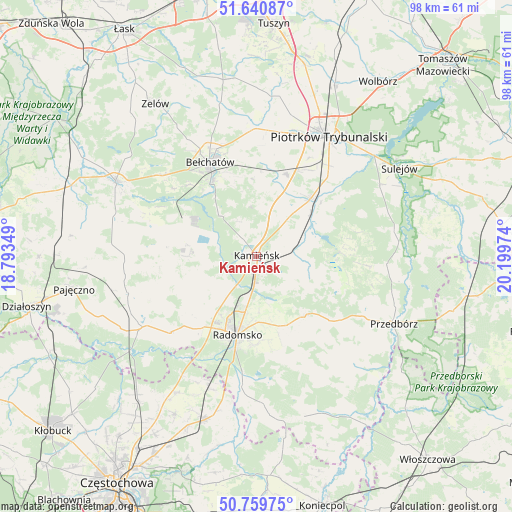
Kamieńsk GPS coordinates[2]
51° 12' 8.712" North, 19° 29' 47.796" East
| Map corner | latitude | longitude |
|---|---|---|
| Upper-left | 51.64087°, | 18.79349° |
| Center: | 51.20242°, | 19.49661° |
| Lower-right: | 50.75975°, | 20.19974° |
| Map W x H: | 98×98 km | = 60.9×60.9mi |
| max Lat: | 54.83135° ⇑49% North |
| Kamieńsk: | 51.20242° |
| min Lat: | ⇓51% South 49.21328° |
| min Long | Kamieńsk | max Long |
| 14.20249° | 19.49661° | 24.03723° |
| W 49.1%⇐ | ⇒50.9% E |
Elevation
Elevation of Kamieńsk is 224 m = 735 ft, and this is 32.6 m = 107 ft above average elevation for this country.
| Max E: |
974 m = 3196 ft | 31.6% |
| Kamieńsk | 224 m 735 ft | |
| Avg. | 191.4 m = 628 ft | |
Min E: |
-3 m = -10 ft | 68.4% |
See also: Poland elevation on elevation.city.
Geographical zone
Kamieńsk is located in North temperate zone (between Tropic of Cancer and the Arctic Circle). Distance of this North polar circle is 1708 km =1061.3 mi to North.| Distance of | km | miles | from Kamieńsk |
|---|---|---|---|
| North Pole | 4313.9 | 2680.5 | to North |
| Arctic Circle | 1708 | 1061.3 | to North |
| Tropic Cancer | 3087.3 | 1918.4 | to South |
| Equator | 5693.2 | 3537.6 | to South |


Nearby cities:
15 places around Kamieńsk: (largest is in red/bold)
• Bełchatów
20.9 km =13 mi,  332°
332°
• Dobroszyce
8.8 km =5.5 mi,  222°
222°
• Gomunice
3.7 km =2.3 mi,  183°
183°
• Gorzkowice
7.1 km =4.4 mi,  78°
78°
• Kleszczów
13.6 km =8.5 mi,  279°
279°
• Kobiele Wielkie
20.3 km =12.6 mi,  154°
154°
• Kodrąb
14.7 km =9.1 mi,  141°
141°
• Lgota Wielka
13.2 km =8.2 mi,  243°
243°
• Radomsko
15.5 km =9.6 mi,  193°
193°
• Radziechowice Pierwsze
19.1 km =11.9 mi, 218°
• Rozprza
15.2 km =9.4 mi,  42°
42°
• Sulmierzyce
21 km =13 mi,  264°
264°
• Wola Krzysztoporska
16.8 km =10.4 mi,  20°
20°
• Łęki Szlacheckie
21.1 km =13.1 mi,  94°
94°
• Łękińsko
10.6 km =6.6 mi, 279°
Sources, notices
• [Note1] Compared only with cities in Poland existing in our database
• [Src1] Map data: © OpenStreetMap contributors (CC-BY-SA)
• [Src2] Other city data from geonames.org with taken over terms of usage.
• [Src3] Geographical zone / Annual Mean Temperature by Robert A. Rohde @ Wikipedia
