Łękińsko geodata
Łękińsko (Łódź Voivodeship) is a populated place; located in Poland in Europe/Warsaw (GMT+2) time zone. With population of 560 people, there are 3377 cities with bigger population in this country. Compared to other cities in Poland, 51.3% of cities are located further ↓South; 53.6% of cities are located further →East and 60.6% of cities have lower elevation than Łękińsko. Note1
Administrative division(s):
- Level 1: Łódź Voivodeship
- Level 2: Powiat bełchatowski
- Level 3: Kleszczów


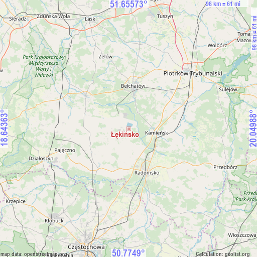
Łękińsko GPS coordinates[2]
51° 13' 2.712" North, 19° 20' 48.3" East
| Map corner | latitude | longitude |
|---|---|---|
| Upper-left | 51.65573°, | 18.64363° |
| Center: | 51.21742°, | 19.34675° |
| Lower-right: | 50.7749°, | 20.04988° |
| Map W x H: | 97.9×97.9 km | = 60.8×60.8mi |
| max Lat: | 54.83135° ⇑48.7% North |
| Łękińsko: | 51.21742° |
| min Lat: | ⇓51.3% South 49.21328° |
| min Long | Łękińsko | max Long |
| 14.20249° | 19.34675° | 24.03723° |
| W 46.4%⇐ | ⇒53.6% E |
Elevation
Elevation of Łękińsko is 202 m = 663 ft, and this is 10.6 m = 35 ft above average elevation for this country.
| Max E: |
974 m = 3196 ft | 39.4% |
| Łękińsko | 202 m 663 ft | |
| Avg. | 191.4 m = 628 ft | |
Min E: |
-3 m = -10 ft | 60.6% |
See also: Poland elevation on elevation.city.
Geographical zone
Łękińsko is located in North temperate zone (between Tropic of Cancer and the Arctic Circle). Distance of this North polar circle is 1706.3 km =1060.2 mi to North.| Distance of | km | miles | from Łękińsko |
|---|---|---|---|
| North Pole | 4312.2 | 2679.5 | to North |
| Arctic Circle | 1706.3 | 1060.2 | to North |
| Tropic Cancer | 3088.9 | 1919.4 | to South |
| Equator | 5694.8 | 3538.6 | to South |


Nearby cities:
15 places around Łękińsko: (largest is in red/bold)
• Bełchatów
16.8 km =10.4 mi,  2°
2°
• Dobroszyce
9.3 km =5.8 mi,  150°
150°
• Gomunice
11.6 km =7.2 mi,  117°
117°
• Gorzkowice
17.4 km =10.8 mi,  90°
90°
• Kamieńsk
10.6 km =6.6 mi,  99°
99°
• Kleszczów
3 km =1.9 mi,  282°
282°
• Kluki
15.7 km =9.8 mi,  331°
331°
• Lgota Wielka
7.7 km =4.8 mi,  190°
190°
• Nowa Brzeźnica
19 km =11.8 mi,  216°
216°
• Radomsko
18.1 km =11.2 mi,  157°
157°
• Radziechowice Pierwsze
16.6 km =10.3 mi, 185°
• Rząśnia
21.1 km =13.1 mi,  270°
270°
• Strzelce Wielkie
16.5 km =10.3 mi,  238°
238°
• Sulmierzyce
11.1 km =6.9 mi,  250°
250°
• Szczerców
20.9 km =13 mi,  307°
307°
Sources, notices
• [Note1] Compared only with cities in Poland existing in our database
• [Src1] Map data: © OpenStreetMap contributors (CC-BY-SA)
• [Src2] Other city data from geonames.org with taken over terms of usage.
• [Src3] Geographical zone / Annual Mean Temperature by Robert A. Rohde @ Wikipedia
