Sulmierzyce geodata
Sulmierzyce (Łódź Voivodeship) is a populated place; located in Poland in Europe/Warsaw (GMT+2) time zone. With population of 1,400 people, there are 1959 cities with bigger population in this country. Compared to other cities in Poland, 50.4% of cities are located further ↓South; 56.1% of cities are located further →East and 68.1% of cities have lower elevation than Sulmierzyce. Note1
Administrative division(s):
- Level 1: Łódź Voivodeship
- Level 2: Powiat pajęczański
- Level 3: Sulmierzyce


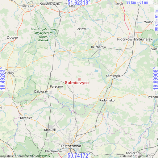
Sulmierzyce GPS coordinates[2]
51° 11' 4.416" North, 19° 11' 45.42" East
| Map corner | latitude | longitude |
|---|---|---|
| Upper-left | 51.62318°, | 18.49283° |
| Center: | 51.18456°, | 19.19595° |
| Lower-right: | 50.74172°, | 19.89908° |
| Map W x H: | 98×98 km | = 60.9×60.9mi |
| max Lat: | 54.83135° ⇑49.6% North |
| Sulmierzyce: | 51.18456° |
| min Lat: | ⇓50.4% South 49.21328° |
| min Long | Sulmierzyce | max Long |
| 14.20249° | 19.19595° | 24.03723° |
| W 43.9%⇐ | ⇒56.1% E |
Elevation
Elevation of Sulmierzyce is 223 m = 732 ft, and this is 31.6 m = 104 ft above average elevation for this country.
| Max E: |
974 m = 3196 ft | 31.9% |
| Sulmierzyce | 223 m 732 ft | |
| Avg. | 191.4 m = 628 ft | |
Min E: |
-3 m = -10 ft | 68.1% |
See also: Poland elevation on elevation.city.
Geographical zone
Sulmierzyce is located in North temperate zone (between Tropic of Cancer and the Arctic Circle). Distance of this North polar circle is 1710 km =1062.5 mi to North.| Distance of | km | miles | from Sulmierzyce |
|---|---|---|---|
| North Pole | 4315.9 | 2681.8 | to North |
| Arctic Circle | 1710 | 1062.5 | to North |
| Tropic Cancer | 3085.3 | 1917.1 | to South |
| Equator | 5691.2 | 3536.3 | to South |


Nearby cities:
15 places around Sulmierzyce: (largest is in red/bold)
• Dobroszyce
15.7 km =9.8 mi,  106°
106°
• Gomunice
20.8 km =12.9 mi,  94°
94°
• Kamieńsk
21 km =13 mi,  84°
84°
• Kiełczygłów
16 km =9.9 mi,  292°
292°
• Kleszczów
8.7 km =5.4 mi,  60°
60°
• Kluki
17.8 km =11.1 mi,  9°
9°
• Lgota Wielka
10 km =6.2 mi, 113°
• Nowa Brzeźnica
11.5 km =7.1 mi,  184°
184°
• Pajęczno
14.6 km =9.1 mi,  252°
252°
• Radziechowice Pierwsze
15.7 km =9.8 mi,  144°
144°
• Rząśnia
11.3 km =7 mi, 290°
• Siemkowice
20.8 km =12.9 mi,  275°
275°
• Strzelce Wielkie
6.1 km =3.8 mi,  215°
215°
• Szczerców
17.6 km =10.9 mi,  340°
340°
• Łękińsko
11.1 km =6.9 mi,  70°
70°
Sources, notices
• [Note1] Compared only with cities in Poland existing in our database
• [Src1] Map data: © OpenStreetMap contributors (CC-BY-SA)
• [Src2] Other city data from geonames.org with taken over terms of usage.
• [Src3] Geographical zone / Annual Mean Temperature by Robert A. Rohde @ Wikipedia
