Lgota Wielka geodata
Lgota Wielka (Łódź Voivodeship) is a seat of a third-order administrative division; located in Poland in Europe/Warsaw (GMT+2) time zone. With population of 636 people, there are 3197 cities with bigger population in this country. Compared to other cities in Poland, 50.4% of cities are located further ↑North; 53.8% of cities are located further →East and 70.6% of cities have lower elevation than Lgota Wielka. Note1
Administrative division(s):
- Level 1: Łódź Voivodeship
- Level 2: Powiat radomszczański
- Level 3: Lgota Wielka


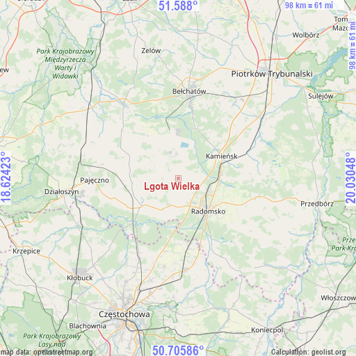
Lgota Wielka GPS coordinates[2]
51° 8' 56.544" North, 19° 19' 38.46" East
| Map corner | latitude | longitude |
|---|---|---|
| Upper-left | 51.588°, | 18.62423° |
| Center: | 51.14904°, | 19.32735° |
| Lower-right: | 50.70586°, | 20.03048° |
| Map W x H: | 98.1×98.1 km | = 61×61mi |
| max Lat: | 54.83135° ⇑50.4% North |
| Lgota Wielka: | 51.14904° |
| min Lat: | ⇓49.6% South 49.21328° |
| min Long | Lgota Wielka | max Long |
| 14.20249° | 19.32735° | 24.03723° |
| W 46.2%⇐ | ⇒53.8% E |
Elevation
Elevation of Lgota Wielka is 231 m = 758 ft, and this is 39.6 m = 130 ft above average elevation for this country.
| Max E: |
974 m = 3196 ft | 29.4% |
| Lgota Wielka | 231 m 758 ft | |
| Avg. | 191.4 m = 628 ft | |
Min E: |
-3 m = -10 ft | 70.6% |
See also: Poland elevation on elevation.city.
Geographical zone
Lgota Wielka is located in North temperate zone (between Tropic of Cancer and the Arctic Circle). Distance of this North polar circle is 1713.9 km =1065 mi to North.| Distance of | km | miles | from Lgota Wielka |
|---|---|---|---|
| North Pole | 4319.8 | 2684.2 | to North |
| Arctic Circle | 1713.9 | 1065 | to North |
| Tropic Cancer | 3081.3 | 1914.6 | to South |
| Equator | 5687.2 | 3533.9 | to South |


Nearby cities:
15 places around Lgota Wielka: (largest is in red/bold)
• Dobroszyce
5.9 km =3.7 mi,  94°
94°
• Gomunice
11.8 km =7.3 mi,  79°
79°
• Gorzkowice
20.1 km =12.5 mi,  68°
68°
• Kamieńsk
13.2 km =8.2 mi,  63°
63°
• Kleszczów
8.4 km =5.2 mi,  348°
348°
• Kodrąb
21.7 km =13.5 mi,  104°
104°
• Kruszyna
20.5 km =12.7 mi,  189°
189°
• Nowa Brzeźnica
12.6 km =7.8 mi,  233°
233°
• Pławno
21 km =13 mi,  154°
154°
• Radomsko
12.3 km =7.6 mi,  138°
138°
• Radziechowice Pierwsze
8.9 km =5.5 mi,  180°
180°
• Rząśnia
21.3 km =13.2 mi,  291°
291°
• Strzelce Wielkie
12.7 km =7.9 mi,  265°
265°
• Sulmierzyce
10 km =6.2 mi, 293°
• Łękińsko
7.7 km =4.8 mi,  10°
10°
Sources, notices
• [Note1] Compared only with cities in Poland existing in our database
• [Src1] Map data: © OpenStreetMap contributors (CC-BY-SA)
• [Src2] Other city data from geonames.org with taken over terms of usage.
• [Src3] Geographical zone / Annual Mean Temperature by Robert A. Rohde @ Wikipedia
