Barwice geodata
Barwice (West Pomerania) is a seat of a third-order administrative division; located in Poland in Europe/Warsaw (GMT+2) time zone. With population of 3,756 people, there are 863 cities with bigger population in this country. Compared to other cities in Poland, 91.7% of cities are located further ↓South; 90.5% of cities are located further →East and 73.5% of cities have higher elevation than Barwice. Note1


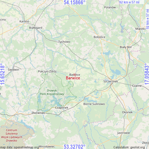
Barwice GPS coordinates[2]
53° 44' 41.64" North, 16° 21' 19.08" East
| Map corner | latitude | longitude |
|---|---|---|
| Upper-left | 54.15866°, | 15.65218° |
| Center: | 53.7449°, | 16.3553° |
| Lower-right: | 53.32702°, | 17.05843° |
| Map W x H: | 92.5×92.5 km | = 57.5×57.5mi |
| max Lat: | 54.83135° ⇑8.3% North |
| Barwice: | 53.7449° |
| min Lat: | ⇓91.7% South 49.21328° |
| min Long | Barwice | max Long |
| 14.20249° | 16.3553° | 24.03723° |
| W 9.5%⇐ | ⇒90.5% E |
Elevation
Elevation of Barwice is 114 m = 374 ft, and this is 77.4 m = 254 ft below average elevation for this country.
| Max E: |
974 m = 3196 ft | 73.5% |
| Avg. | 191.4 m = 628 ft | |
| Barwice | 114 m = 374 ft | |
Min E: |
-3 m = -10 ft | 26.5% |
See also: Poland elevation on elevation.city.
Geographical zone
Barwice is located in North temperate zone (between Tropic of Cancer and the Arctic Circle). Distance of this North polar circle is 1425.3 km =885.6 mi to North.| Distance of | km | miles | from Barwice |
|---|---|---|---|
| North Pole | 4031.2 | 2504.9 | to North |
| Arctic Circle | 1425.3 | 885.6 | to North |
| Tropic Cancer | 3370 | 2094 | to South |
| Equator | 5975.9 | 3713.3 | to South |


Nearby cities:
15 places around Barwice: (largest is in red/bold)
• Biały Bór
35.7 km =22.2 mi,  61°
61°
• Bobolice
27.9 km =17.3 mi,  33°
33°
• Borne Sulinowo
22.1 km =13.7 mi,  147°
147°
• Czaplinek
22.3 km =13.9 mi,  201°
201°
• Grzmiąca
11.5 km =7.1 mi, 27°
• Połczyn-Zdrój
17.2 km =10.7 mi,  277°
277°
• Rąbino
30.1 km =18.7 mi,  296°
296°
• Sitno
22.6 km =14 mi,  115°
115°
• Sypniewo
34.9 km =21.7 mi, 151°
• Szczecinek
23 km =14.3 mi,  100°
100°
• Tychowo
21.3 km =13.2 mi,  342°
342°
• Wierzchowo
35.9 km =22.3 mi,  208°
208°
• Złocieniec
32.7 km =20.3 mi,  223°
223°
• Łubowo
17.8 km =11.1 mi,  172°
172°
• Żółtnica
30.9 km =19.2 mi, 104°
Sources, notices
• [Note1] Compared only with cities in Poland existing in our database
• [Src1] Map data: © OpenStreetMap contributors (CC-BY-SA)
• [Src2] Other city data from geonames.org with taken over terms of usage.
• [Src3] Geographical zone / Annual Mean Temperature by Robert A. Rohde @ Wikipedia
