Przyborów geodata
Przyborów (Lubusz) is a populated place; located in Poland in Europe/Warsaw (GMT+2) time zone. With population of 1,200 people, there are 2164 cities with bigger population in this country. Compared to other cities in Poland, 62.1% of cities are located further ↓South; 93.8% of cities are located further →East and 92.4% of cities have higher elevation than Przyborów. Note1


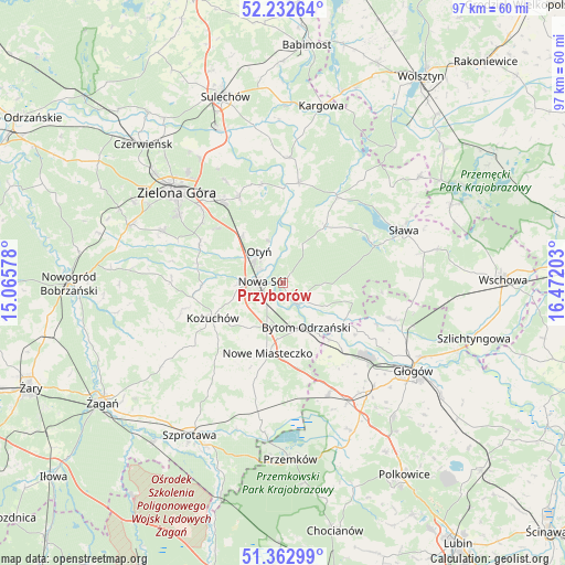
Przyborów GPS coordinates[2]
51° 47' 59.676" North, 15° 46' 8.04" East
| Map corner | latitude | longitude |
|---|---|---|
| Upper-left | 52.23264°, | 15.06578° |
| Center: | 51.79991°, | 15.7689° |
| Lower-right: | 51.36299°, | 16.47203° |
| Map W x H: | 96.7×96.7 km | = 60.1×60.1mi |
| max Lat: | 54.83135° ⇑37.9% North |
| Przyborów: | 51.79991° |
| min Lat: | ⇓62.1% South 49.21328° |
| min Long | Przyborów | max Long |
| 14.20249° | 15.7689° | 24.03723° |
| W 6.2%⇐ | ⇒93.8% E |
Elevation
Elevation of Przyborów is 63 m = 207 ft, and this is 128.4 m = 421 ft below average elevation for this country.
| Max E: |
974 m = 3196 ft | 92.4% |
| Avg. | 191.4 m = 628 ft | |
| Przyborów | 63 m = 207 ft | |
Min E: |
-3 m = -10 ft | 7.6% |
See also: Poland elevation on elevation.city.
Geographical zone
Przyborów is located in North temperate zone (between Tropic of Cancer and the Arctic Circle). Distance of this North polar circle is 1641.6 km =1020 mi to North.| Distance of | km | miles | from Przyborów |
|---|---|---|---|
| North Pole | 4247.5 | 2639.3 | to North |
| Arctic Circle | 1641.6 | 1020 | to North |
| Tropic Cancer | 3153.7 | 1959.6 | to South |
| Equator | 5759.6 | 3578.8 | to South |


Nearby cities:
15 places around Przyborów: (largest is in red/bold)
• Bielawy
12.1 km =7.5 mi,  106°
106°
• Bobrowniki
7.7 km =4.8 mi,  340°
340°
• Bojadła
17.3 km =10.7 mi,  9°
9°
• Bytom Odrzański
8.6 km =5.3 mi,  153°
153°
• Gaworzyce
20.7 km =12.9 mi,  157°
157°
• Konotop
17.3 km =10.7 mi,  32°
32°
• Kotla
19.3 km =12 mi, 108°
• Kożuchów
13.4 km =8.3 mi,  243°
243°
• Lubięcin
12.5 km =7.8 mi,  36°
36°
• Nowa Sól
3.6 km =2.2 mi,  276°
276°
• Nowe Miasteczko
12.4 km =7.7 mi,  191°
191°
• Otyń
6.6 km =4.1 mi,  323°
323°
• Siedlisko
4.7 km =2.9 mi,  138°
138°
• Zabór
17.3 km =10.7 mi,  348°
348°
• Żukowice
20.4 km =12.7 mi,  133°
133°
Sources, notices
• [Note1] Compared only with cities in Poland existing in our database
• [Src1] Map data: © OpenStreetMap contributors (CC-BY-SA)
• [Src2] Other city data from geonames.org with taken over terms of usage.
• [Src3] Geographical zone / Annual Mean Temperature by Robert A. Rohde @ Wikipedia
