Łączany geodata
Łączany (Lesser Poland) is a populated place; located in Poland in Europe/Warsaw (GMT+2) time zone. With population of 1,589 people, there are 1781 cities with bigger population in this country. Compared to other cities in Poland, 83.5% of cities are located further ↑North; 50.4% of cities are located further ←West and 64.5% of cities have lower elevation than Łączany. Note1


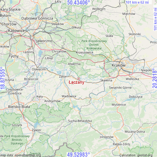
Łączany GPS coordinates[2]
49° 59' 2.652" North, 19° 34' 43.212" East
| Map corner | latitude | longitude |
|---|---|---|
| Upper-left | 50.43406°, | 18.87555° |
| Center: | 49.98407°, | 19.57867° |
| Lower-right: | 49.52983°, | 20.2818° |
| Map W x H: | 100.5×100.5 km | = 62.4×62.4mi |
| max Lat: | 54.83135° ⇑83.5% North |
| Łączany: | 49.98407° |
| min Lat: | ⇓16.5% South 49.21328° |
| min Long | Łączany | max Long |
| 14.20249° | 19.57867° | 24.03723° |
| W 50.4%⇐ | ⇒49.6% E |
Elevation
Elevation of Łączany is 213 m = 699 ft, and this is 21.6 m = 71 ft above average elevation for this country.
| Max E: |
974 m = 3196 ft | 35.5% |
| Łączany | 213 m 699 ft | |
| Avg. | 191.4 m = 628 ft | |
Min E: |
-3 m = -10 ft | 64.5% |
See also: Poland elevation on elevation.city.
Geographical zone
Łączany is located in North temperate zone (between Tropic of Cancer and the Arctic Circle). Distance of this North polar circle is 1843.5 km =1145.5 mi to North.| Distance of | km | miles | from Łączany |
|---|---|---|---|
| North Pole | 4449.4 | 2764.7 | to North |
| Arctic Circle | 1843.5 | 1145.5 | to North |
| Tropic Cancer | 2951.8 | 1834.2 | to South |
| Equator | 5557.7 | 3453.4 | to South |


Nearby cities:
15 places around Łączany: (largest is in red/bold)
• Bachowice
6.7 km =4.2 mi,  244°
244°
• Brodła
6.6 km =4.1 mi,  6°
6°
• Brzeźnica
3.6 km =2.2 mi,  126°
126°
• Bęczyn
8 km =5 mi, 132°
• Czernichów
7.3 km =4.5 mi,  85°
85°
• Kamień
3.2 km =2 mi, 8°
• Marcyporęba
5 km =3.1 mi,  150°
150°
• Okleśna
6.2 km =3.9 mi,  326°
326°
• Przeginia Duchowna
6.7 km =4.2 mi,  52°
52°
• Przeginia Narodowa
6.4 km =4 mi,  63°
63°
• Rusocice
2.4 km =1.5 mi, 56°
• Ryczów
2.1 km =1.3 mi,  260°
260°
• Spytkowice
5 km =3.1 mi,  286°
286°
• Witanowice
8.3 km =5.2 mi,  207°
207°
• Woźniki
8.1 km =5 mi,  230°
230°
Sources, notices
• [Note1] Compared only with cities in Poland existing in our database
• [Src1] Map data: © OpenStreetMap contributors (CC-BY-SA)
• [Src2] Other city data from geonames.org with taken over terms of usage.
• [Src3] Geographical zone / Annual Mean Temperature by Robert A. Rohde @ Wikipedia
