Kamień geodata
Kamień (Lesser Poland) is a populated place; located in Poland in Europe/Warsaw (GMT+2) time zone. With population of 1,470 people, there are 1899 cities with bigger population in this country. Compared to other cities in Poland, 81.9% of cities are located further ↑North; 50.5% of cities are located further ←West and 78.5% of cities have lower elevation than Kamień. Note1


Kamień GPS coordinates[2]
50° 0' 43.74" North, 19° 35' 7.296" East
| Map corner | latitude | longitude |
|---|---|---|
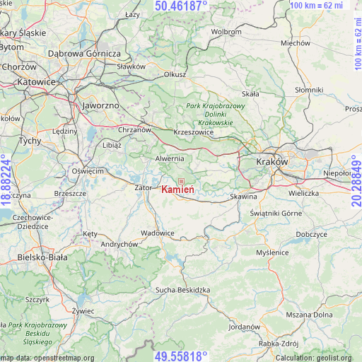
| Upper-left | 50.46187°, | 18.88224° |
| Center: | 50.01215°, | 19.58536° |
| Lower-right: | 49.55818°, | 20.28849° |
| Map W x H: | 100.5×100.5 km | = 62.4×62.4mi |
| max Lat: | 54.83135° ⇑81.9% North |
| Kamień: | 50.01215° |
| min Lat: | ⇓18.1% South 49.21328° |
| min Long | Kamień | max Long |
| 14.20249° | 19.58536° | 24.03723° |
| W 50.5%⇐ | ⇒49.5% E |
Elevation
Elevation of Kamień is 259 m = 850 ft, and this is 67.6 m = 222 ft above average elevation for this country.
| Max E: |
974 m = 3196 ft | 21.5% |
| Kamień | 259 m 850 ft | |
| Avg. | 191.4 m = 628 ft | |
Min E: |
-3 m = -10 ft | 78.5% |
See also: Poland elevation on elevation.city.
Geographical zone
Kamień is located in North temperate zone (between Tropic of Cancer and the Arctic Circle). Distance of this North polar circle is 1840.3 km =1143.5 mi to North.| Distance of | km | miles | from Kamień |
|---|---|---|---|
| North Pole | 4446.2 | 2762.7 | to North |
| Arctic Circle | 1840.3 | 1143.5 | to North |
| Tropic Cancer | 2954.9 | 1836.1 | to South |
| Equator | 5560.8 | 3455.3 | to South |


Nearby cities:
15 places around Kamień: (largest is in red/bold)
• Alwernia
6.3 km =3.9 mi,  328°
328°
• Brodła
3.5 km =2.2 mi,  4°
4°
• Brzeźnica
5.8 km =3.6 mi,  155°
155°
• Czernichów
7.3 km =4.5 mi,  110°
110°
• Marcyporęba
7.7 km =4.8 mi, 164°
• Okleśna
4.4 km =2.7 mi,  298°
298°
• Przeginia Duchowna
5 km =3.1 mi,  78°
78°
• Przeginia Narodowa
5.3 km =3.3 mi,  92°
92°
• Rozkochów
7.7 km =4.8 mi, 298°
• Rusocice
2.3 km =1.4 mi,  139°
139°
• Ryczów
4.3 km =2.7 mi,  216°
216°
• Sanka
7.6 km =4.7 mi,  34°
34°
• Spytkowice
5.6 km =3.5 mi,  252°
252°
• Zalas
8 km =5 mi,  18°
18°
• Łączany
3.2 km =2 mi,  188°
188°
Sources, notices
• [Note1] Compared only with cities in Poland existing in our database
• [Src1] Map data: © OpenStreetMap contributors (CC-BY-SA)
• [Src2] Other city data from geonames.org with taken over terms of usage.
• [Src3] Geographical zone / Annual Mean Temperature by Robert A. Rohde @ Wikipedia
