Wołów geodata
Wołów (Lower Silesia) is a populated place; located in Poland in Europe/Warsaw (GMT+2) time zone. With population of 12,276 people, there are 387 cities with bigger population in this country. Compared to other cities in Poland, 53.8% of cities are located further ↓South; 88.5% of cities are located further →East and 74% of cities have higher elevation than Wołów. Note1


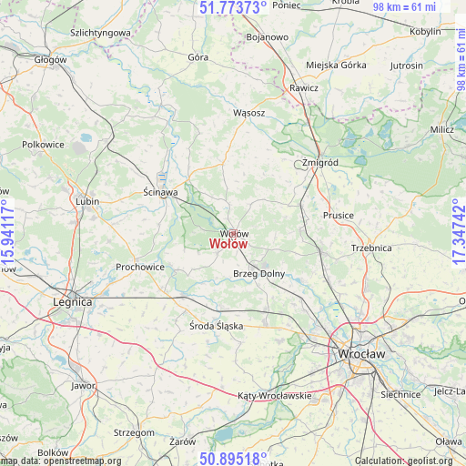
Wołów GPS coordinates[2]
51° 20' 11.616" North, 16° 38' 39.444" East
| Map corner | latitude | longitude |
|---|---|---|
| Upper-left | 51.77373°, | 15.94117° |
| Center: | 51.33656°, | 16.64429° |
| Lower-right: | 50.89518°, | 17.34742° |
| Map W x H: | 97.7×97.7 km | = 60.7×60.7mi |
| max Lat: | 54.83135° ⇑46.2% North |
| Wołów: | 51.33656° |
| min Lat: | ⇓53.8% South 49.21328° |
| min Long | Wołów | max Long |
| 14.20249° | 16.64429° | 24.03723° |
| W 11.5%⇐ | ⇒88.5% E |
Elevation
Elevation of Wołów is 113 m = 371 ft, and this is 78.4 m = 257 ft below average elevation for this country.
| Max E: |
974 m = 3196 ft | 74% |
| Avg. | 191.4 m = 628 ft | |
| Wołów | 113 m = 371 ft | |
Min E: |
-3 m = -10 ft | 26% |
See also: Poland elevation on elevation.city.
Geographical zone
Wołów is located in North temperate zone (between Tropic of Cancer and the Arctic Circle). Distance of this North polar circle is 1693.1 km =1052 mi to North.| Distance of | km | miles | from Wołów |
|---|---|---|---|
| North Pole | 4299 | 2671.3 | to North |
| Arctic Circle | 1693.1 | 1052 | to North |
| Tropic Cancer | 3102.2 | 1927.6 | to South |
| Equator | 5708.1 | 3546.8 | to South |


Nearby cities:
15 places around Wołów: (largest is in red/bold)
• Brzeg Dolny
8.3 km =5.2 mi,  147°
147°
• Jemielno
22 km =13.7 mi,  341°
341°
• Lisowice
21.3 km =13.2 mi,  255°
255°
• Malczyce
16.6 km =10.3 mi,  219°
219°
• Miękinia
17.7 km =11 mi,  158°
158°
• Mrozów
19.3 km =12 mi, 148°
• Oborniki Śląskie
19.2 km =11.9 mi,  101°
101°
• Prochowice
20.6 km =12.8 mi,  249°
249°
• Prusice
22.3 km =13.9 mi,  80°
80°
• Szczepanów
15.6 km =9.7 mi,  188°
188°
• Uraz
17.3 km =10.7 mi,  123°
123°
• Wińsko
15 km =9.3 mi,  351°
351°
• Ścinawa
17.6 km =10.9 mi,  300°
300°
• Środa Śląska
19.5 km =12.1 mi, 190°
• Żmigród
23.2 km =14.4 mi,  51°
51°
Sources, notices
• [Note1] Compared only with cities in Poland existing in our database
• [Src1] Map data: © OpenStreetMap contributors (CC-BY-SA)
• [Src2] Other city data from geonames.org with taken over terms of usage.
• [Src3] Geographical zone / Annual Mean Temperature by Robert A. Rohde @ Wikipedia
