Sokolniki geodata
Sokolniki (Greater Poland) is a populated place; located in Poland in Europe/Warsaw (GMT+2) time zone. With population of 570 people, there are 3357 cities with bigger population in this country. Compared to other cities in Poland, 71.4% of cities are located further ↓South; 78.2% of cities are located further →East and 84.1% of cities have higher elevation than Sokolniki. Note1


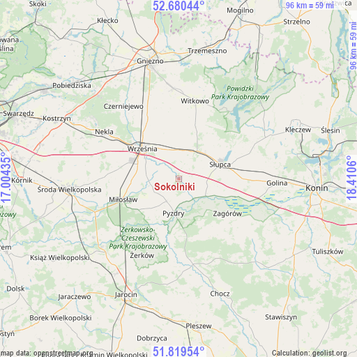
Sokolniki GPS coordinates[2]
52° 15' 7.488" North, 17° 42' 26.892" East
| Map corner | latitude | longitude |
|---|---|---|
| Upper-left | 52.68044°, | 17.00435° |
| Center: | 52.25208°, | 17.70747° |
| Lower-right: | 51.81954°, | 18.4106° |
| Map W x H: | 95.7×95.7 km | = 59.5×59.5mi |
| max Lat: | 54.83135° ⇑28.6% North |
| Sokolniki: | 52.25208° |
| min Lat: | ⇓71.4% South 49.21328° |
| min Long | Sokolniki | max Long |
| 14.20249° | 17.70747° | 24.03723° |
| W 21.8%⇐ | ⇒78.2% E |
Elevation
Elevation of Sokolniki is 91 m = 299 ft, and this is 100.4 m = 329 ft below average elevation for this country.
| Max E: |
974 m = 3196 ft | 84.1% |
| Avg. | 191.4 m = 628 ft | |
| Sokolniki | 91 m = 299 ft | |
Min E: |
-3 m = -10 ft | 15.9% |
See also: Poland elevation on elevation.city.
Geographical zone
Sokolniki is located in North temperate zone (between Tropic of Cancer and the Arctic Circle). Distance of this North polar circle is 1591.3 km =988.8 mi to North.| Distance of | km | miles | from Sokolniki |
|---|---|---|---|
| North Pole | 4197.2 | 2608 | to North |
| Arctic Circle | 1591.3 | 988.8 | to North |
| Tropic Cancer | 3204 | 1990.9 | to South |
| Equator | 5809.9 | 3610.1 | to South |


Nearby cities:
15 places around Sokolniki: (largest is in red/bold)
• Grabowo Królewskie
6 km =3.7 mi,  258°
258°
• Kołaczkowo
6.9 km =4.3 mi,  235°
235°
• Lisewo
18.8 km =11.7 mi,  182°
182°
• Lądek
15.9 km =9.9 mi,  107°
107°
• Miłosław
15.8 km =9.8 mi,  249°
249°
• Nekla
23.6 km =14.7 mi,  302°
302°
• Powidz
23 km =14.3 mi,  38°
38°
• Pyzdry
9.1 km =5.7 mi,  187°
187°
• Strzałkowo
9.7 km =6 mi,  50°
50°
• Słupca
11.9 km =7.4 mi,  70°
70°
• Tomice
20.7 km =12.9 mi,  174°
174°
• Witkowo
21.3 km =13.2 mi,  11°
11°
• Września
12.6 km =7.8 mi,  310°
310°
• Zagórów
15.8 km =9.8 mi,  125°
125°
• Żerków
22.6 km =14 mi,  205°
205°
Sources, notices
• [Note1] Compared only with cities in Poland existing in our database
• [Src1] Map data: © OpenStreetMap contributors (CC-BY-SA)
• [Src2] Other city data from geonames.org with taken over terms of usage.
• [Src3] Geographical zone / Annual Mean Temperature by Robert A. Rohde @ Wikipedia
