Bojanowo geodata
Bojanowo (Greater Poland) is a seat of a third-order administrative division; located in Poland in Europe/Warsaw (GMT+2) time zone. With population of 2,960 people, there are 1068 cities with bigger population in this country. Compared to other cities in Poland, 60.3% of cities are located further ↓South; 87.6% of cities are located further →East and 72.6% of cities have higher elevation than Bojanowo. Note1


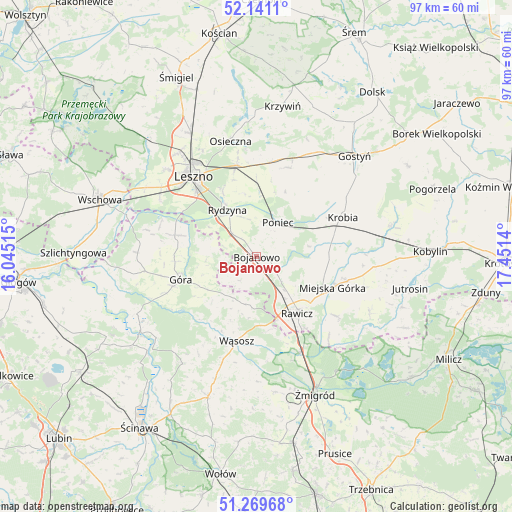
Bojanowo GPS coordinates[2]
51° 42' 26.964" North, 16° 44' 53.772" East
| Map corner | latitude | longitude |
|---|---|---|
| Upper-left | 52.1411°, | 16.04515° |
| Center: | 51.70749°, | 16.74827° |
| Lower-right: | 51.26968°, | 17.4514° |
| Map W x H: | 96.9×96.9 km | = 60.2×60.2mi |
| max Lat: | 54.83135° ⇑39.7% North |
| Bojanowo: | 51.70749° |
| min Lat: | ⇓60.3% South 49.21328° |
| min Long | Bojanowo | max Long |
| 14.20249° | 16.74827° | 24.03723° |
| W 12.4%⇐ | ⇒87.6% E |
Elevation
Elevation of Bojanowo is 116 m = 381 ft, and this is 75.4 m = 247 ft below average elevation for this country.
| Max E: |
974 m = 3196 ft | 72.6% |
| Avg. | 191.4 m = 628 ft | |
| Bojanowo | 116 m = 381 ft | |
Min E: |
-3 m = -10 ft | 27.4% |
See also: Poland elevation on elevation.city.
Geographical zone
Bojanowo is located in North temperate zone (between Tropic of Cancer and the Arctic Circle). Distance of this North polar circle is 1651.8 km =1026.4 mi to North.| Distance of | km | miles | from Bojanowo |
|---|---|---|---|
| North Pole | 4257.7 | 2645.6 | to North |
| Arctic Circle | 1651.8 | 1026.4 | to North |
| Tropic Cancer | 3143.4 | 1953.2 | to South |
| Equator | 5749.3 | 3572.4 | to South |


Nearby cities:
15 places around Bojanowo: (largest is in red/bold)
• Chojno
20.1 km =12.5 mi,  116°
116°
• Chróścina
14.9 km =9.3 mi,  285°
285°
• Dębno Polskie
16.3 km =10.1 mi,  146°
146°
• Golina Wielka
2.6 km =1.6 mi,  108°
108°
• Góra
15.4 km =9.6 mi,  252°
252°
• Krobia
17.7 km =11 mi,  65°
65°
• Krzemieniewo
17.8 km =11.1 mi,  19°
19°
• Leszno
19 km =11.8 mi,  321°
321°
• Miejska Górka
15.6 km =9.7 mi, 111°
• Poniec
7.5 km =4.7 mi,  33°
33°
• Rawicz
13.3 km =8.3 mi, 145°
• Rydzyna
10.4 km =6.5 mi,  327°
327°
• Szymanowo
15.2 km =9.4 mi,  138°
138°
• Słupia Kapitulna
18.3 km =11.4 mi,  127°
127°
• Wąsosz
16.6 km =10.3 mi,  193°
193°
Sources, notices
• [Note1] Compared only with cities in Poland existing in our database
• [Src1] Map data: © OpenStreetMap contributors (CC-BY-SA)
• [Src2] Other city data from geonames.org with taken over terms of usage.
• [Src3] Geographical zone / Annual Mean Temperature by Robert A. Rohde @ Wikipedia
