Ziębice geodata
Ziębice (Lower Silesia) is a seat of a third-order administrative division; located in Poland in Europe/Warsaw (GMT+2) time zone. With population of 9,328 people, there are 466 cities with bigger population in this country. Compared to other cities in Poland, 65% of cities are located further ↑North; 84.1% of cities are located further →East and 67.1% of cities have lower elevation than Ziębice. Note1


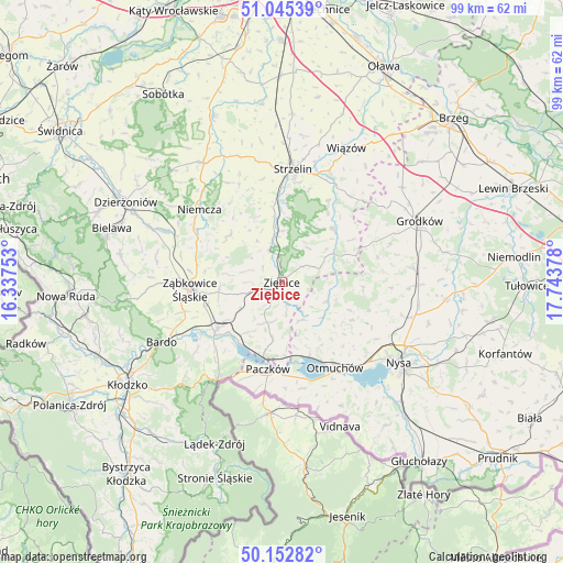
Ziębice GPS coordinates[2]
50° 36' 4.392" North, 17° 2' 26.34" East
| Map corner | latitude | longitude |
|---|---|---|
| Upper-left | 51.04539°, | 16.33753° |
| Center: | 50.60122°, | 17.04065° |
| Lower-right: | 50.15282°, | 17.74378° |
| Map W x H: | 99.2×99.2 km | = 61.6×61.6mi |
| max Lat: | 54.83135° ⇑65% North |
| Ziębice: | 50.60122° |
| min Lat: | ⇓35% South 49.21328° |
| min Long | Ziębice | max Long |
| 14.20249° | 17.04065° | 24.03723° |
| W 15.9%⇐ | ⇒84.1% E |
Elevation
Elevation of Ziębice is 220 m = 722 ft, and this is 28.6 m = 94 ft above average elevation for this country.
| Max E: |
974 m = 3196 ft | 32.9% |
| Ziębice | 220 m 722 ft | |
| Avg. | 191.4 m = 628 ft | |
Min E: |
-3 m = -10 ft | 67.1% |
See also: Poland elevation on elevation.city.
Geographical zone
Ziębice is located in North temperate zone (between Tropic of Cancer and the Arctic Circle). Distance of this North polar circle is 1774.8 km =1102.8 mi to North.| Distance of | km | miles | from Ziębice |
|---|---|---|---|
| North Pole | 4380.7 | 2722 | to North |
| Arctic Circle | 1774.8 | 1102.8 | to North |
| Tropic Cancer | 3020.4 | 1876.8 | to South |
| Equator | 5626.3 | 3496 | to South |


Nearby cities:
15 places around Ziębice: (largest is in red/bold)
• Bobolice
13.1 km =8.1 mi,  280°
280°
• Ciepłowody
12.4 km =7.7 mi,  311°
311°
• Henryków
6.2 km =3.9 mi,  339°
339°
• Kamienica
17.9 km =11.1 mi,  200°
200°
• Kamieniec Ząbkowicki
14.2 km =8.8 mi,  233°
233°
• Kamiennik
8.4 km =5.2 mi,  114°
114°
• Maciejowice
13 km =8.1 mi,  148°
148°
• Niedźwiedź
7.5 km =4.7 mi, 201°
• Niemcza
19.6 km =12.2 mi, 312°
• Otmuchów
17.7 km =11 mi, 147°
• Paczków
15.5 km =9.6 mi,  188°
188°
• Przeworno
12.9 km =8 mi,  43°
43°
• Strzelin
20.1 km =12.5 mi,  4°
4°
• Tarnów
17.8 km =11.1 mi,  261°
261°
• Ząbkowice Śląskie
16.2 km =10.1 mi,  265°
265°
Sources, notices
• [Note1] Compared only with cities in Poland existing in our database
• [Src1] Map data: © OpenStreetMap contributors (CC-BY-SA)
• [Src2] Other city data from geonames.org with taken over terms of usage.
• [Src3] Geographical zone / Annual Mean Temperature by Robert A. Rohde @ Wikipedia
