Stara Dąbrowa geodata
Stara Dąbrowa (West Pomerania) is a seat of a third-order administrative division; located in Poland in Europe/Warsaw (GMT+2) time zone. With population of 618 people, there are 3234 cities with bigger population in this country. Compared to other cities in Poland, 88.8% of cities are located further ↓South; 97.1% of cities are located further →East and 92.9% of cities have higher elevation than Stara Dąbrowa. Note1
Administrative division(s):
- Level 1: West Pomerania
- Level 2: Powiat stargardzki
- Level 3: Stara Dąbrowa


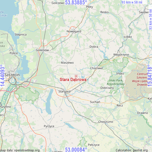
Stara Dąbrowa GPS coordinates[2]
53° 25' 18.876" North, 15° 8' 38.58" East
| Map corner | latitude | longitude |
|---|---|---|
| Upper-left | 53.83885°, | 14.44093° |
| Center: | 53.42191°, | 15.14405° |
| Lower-right: | 53.00084°, | 15.84718° |
| Map W x H: | 93.2×93.2 km | = 57.9×57.9mi |
| max Lat: | 54.83135° ⇑11.2% North |
| Stara Dąbrowa: | 53.42191° |
| min Lat: | ⇓88.8% South 49.21328° |
| min Long | Stara Dąbrowa | max Long |
| 14.20249° | 15.14405° | 24.03723° |
| W 2.9%⇐ | ⇒97.1% E |
Elevation
Elevation of Stara Dąbrowa is 60 m = 197 ft, and this is 131.4 m = 431 ft below average elevation for this country.
| Max E: |
974 m = 3196 ft | 92.9% |
| Avg. | 191.4 m = 628 ft | |
| Stara Dąbrowa | 60 m = 197 ft | |
Min E: |
-3 m = -10 ft | 7.1% |
See also: Poland elevation on elevation.city.
Geographical zone
Stara Dąbrowa is located in North temperate zone (between Tropic of Cancer and the Arctic Circle). Distance of this North polar circle is 1461.2 km =907.9 mi to North.| Distance of | km | miles | from Stara Dąbrowa |
|---|---|---|---|
| North Pole | 4067.1 | 2527.2 | to North |
| Arctic Circle | 1461.2 | 907.9 | to North |
| Tropic Cancer | 3334 | 2071.7 | to South |
| Equator | 5940 | 3690.9 | to South |


Nearby cities:
15 places around Stara Dąbrowa: (largest is in red/bold)
• Chociwel
13.5 km =8.4 mi,  68°
68°
• Dobra
21.3 km =13.2 mi,  30°
30°
• Dobrzany
20.1 km =12.5 mi,  110°
110°
• Dolice
26 km =16.2 mi,  171°
171°
• Goleniów
26.2 km =16.3 mi,  307°
307°
• Ińsko
27 km =16.8 mi,  86°
86°
• Kobylanka
20 km =12.4 mi,  244°
244°
• Marianowo
9.2 km =5.7 mi,  118°
118°
• Maszewo
9.9 km =6.2 mi,  326°
326°
• Morzyczyn
16.8 km =10.4 mi, 242°
• Mosty
18.7 km =11.6 mi,  318°
318°
• Osina
22.1 km =13.7 mi,  336°
336°
• Stargard
11.3 km =7 mi,  213°
213°
• Suchań
19.8 km =12.3 mi,  142°
142°
• Warnice
21.2 km =13.2 mi, 208°
Sources, notices
• [Note1] Compared only with cities in Poland existing in our database
• [Src1] Map data: © OpenStreetMap contributors (CC-BY-SA)
• [Src2] Other city data from geonames.org with taken over terms of usage.
• [Src3] Geographical zone / Annual Mean Temperature by Robert A. Rohde @ Wikipedia
