Dąbrowa geodata
Dąbrowa (Opole Voivodeship) is a populated place; located in Poland in Europe/Warsaw (GMT+2) time zone. With population of 1,100 people, there are 2307 cities with bigger population in this country. Compared to other cities in Poland, 62.9% of cities are located further ↑North; 77.7% of cities are located further →East and 51.6% of cities have higher elevation than Dąbrowa. Note1


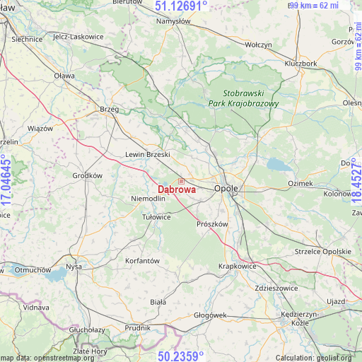
Dąbrowa GPS coordinates[2]
50° 41' 0.672" North, 17° 44' 58.452" East
| Map corner | latitude | longitude |
|---|---|---|
| Upper-left | 51.12691°, | 17.04645° |
| Center: | 50.68352°, | 17.74957° |
| Lower-right: | 50.2359°, | 18.4527° |
| Map W x H: | 99.1×99.1 km | = 61.6×61.6mi |
| max Lat: | 54.83135° ⇑62.9% North |
| Dąbrowa: | 50.68352° |
| min Lat: | ⇓37.1% South 49.21328° |
| min Long | Dąbrowa | max Long |
| 14.20249° | 17.74957° | 24.03723° |
| W 22.3%⇐ | ⇒77.7% E |
Elevation
Elevation of Dąbrowa is 168 m = 551 ft, and this is 23.4 m = 77 ft below average elevation for this country.
| Max E: |
974 m = 3196 ft | 51.6% |
| Avg. | 191.4 m = 628 ft | |
| Dąbrowa | 168 m = 551 ft | |
Min E: |
-3 m = -10 ft | 48.4% |
See also: Poland elevation on elevation.city.
Geographical zone
Dąbrowa is located in North temperate zone (between Tropic of Cancer and the Arctic Circle). Distance of this North polar circle is 1765.7 km =1097.2 mi to North.| Distance of | km | miles | from Dąbrowa |
|---|---|---|---|
| North Pole | 4371.6 | 2716.4 | to North |
| Arctic Circle | 1765.7 | 1097.2 | to North |
| Tropic Cancer | 3029.6 | 1882.5 | to South |
| Equator | 5635.5 | 3501.7 | to South |


Nearby cities:
15 places around Dąbrowa: (largest is in red/bold)
• Borkowice
6.8 km =4.2 mi,  339°
339°
• Chmielowice
9.1 km =5.7 mi,  114°
114°
• Chrościna
5.2 km =3.2 mi, 112°
• Chróścice
11.7 km =7.3 mi,  22°
22°
• Czarnowąsy
11.6 km =7.2 mi,  64°
64°
• Dobrzeń Wielki
11.6 km =7.2 mi,  35°
35°
• Karczów
3.3 km =2.1 mi,  48°
48°
• Komprachcice
7.5 km =4.7 mi,  133°
133°
• Lewin Brzeski
11.8 km =7.3 mi,  307°
307°
• Niemodlin
10.3 km =6.4 mi,  243°
243°
• Opole
12.4 km =7.7 mi,  95°
95°
• Prószków
14.7 km =9.1 mi,  144°
144°
• Skorogoszcz
9.7 km =6 mi,  330°
330°
• Swierkle
15.6 km =9.7 mi, 54°
• Tułowice
11.9 km =7.4 mi,  214°
214°
Sources, notices
• [Note1] Compared only with cities in Poland existing in our database
• [Src1] Map data: © OpenStreetMap contributors (CC-BY-SA)
• [Src2] Other city data from geonames.org with taken over terms of usage.
• [Src3] Geographical zone / Annual Mean Temperature by Robert A. Rohde @ Wikipedia
