Komprachcice geodata
Komprachcice (Opole Voivodeship) is a populated place; located in Poland in Europe/Warsaw (GMT+2) time zone. With population of 2,800 people, there are 1120 cities with bigger population in this country. Compared to other cities in Poland, 64.3% of cities are located further ↑North; 76.9% of cities are located further →East and 51.3% of cities have higher elevation than Komprachcice. Note1
Administrative division(s):
- Level 1: Opole Voivodeship
- Level 2: Powiat opolski
- Level 3: Komprachcice


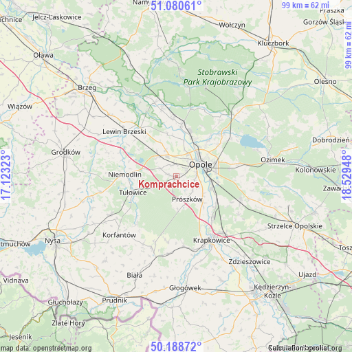
Komprachcice GPS coordinates[2]
50° 38' 12.408" North, 17° 49' 34.86" East
| Map corner | latitude | longitude |
|---|---|---|
| Upper-left | 51.08061°, | 17.12323° |
| Center: | 50.63678°, | 17.82635° |
| Lower-right: | 50.18872°, | 18.52948° |
| Map W x H: | 99.2×99.2 km | = 61.6×61.6mi |
| max Lat: | 54.83135° ⇑64.3% North |
| Komprachcice: | 50.63678° |
| min Lat: | ⇓35.7% South 49.21328° |
| min Long | Komprachcice | max Long |
| 14.20249° | 17.82635° | 24.03723° |
| W 23.1%⇐ | ⇒76.9% E |
Elevation
Elevation of Komprachcice is 169 m = 554 ft, and this is 22.4 m = 73 ft below average elevation for this country.
| Max E: |
974 m = 3196 ft | 51.3% |
| Avg. | 191.4 m = 628 ft | |
| Komprachcice | 169 m = 554 ft | |
Min E: |
-3 m = -10 ft | 48.7% |
See also: Poland elevation on elevation.city.
Geographical zone
Komprachcice is located in North temperate zone (between Tropic of Cancer and the Arctic Circle). Distance of this North polar circle is 1770.9 km =1100.4 mi to North.| Distance of | km | miles | from Komprachcice |
|---|---|---|---|
| North Pole | 4376.8 | 2719.6 | to North |
| Arctic Circle | 1770.9 | 1100.4 | to North |
| Tropic Cancer | 3024.4 | 1879.3 | to South |
| Equator | 5630.3 | 3498.5 | to South |


Nearby cities:
15 places around Komprachcice: (largest is in red/bold)
• Borkowice
14 km =8.7 mi,  326°
326°
• Chmielowice
3.2 km =2 mi,  63°
63°
• Chrościna
3.3 km =2.1 mi,  349°
349°
• Chróścice
16 km =9.9 mi,  356°
356°
• Czarnowąsy
11.4 km =7.1 mi,  26°
26°
• Dobrzeń Wielki
14.7 km =9.1 mi,  5°
5°
• Dąbrowa
7.5 km =4.7 mi,  313°
313°
• Karczów
8 km =5 mi,  338°
338°
• Kąty Opolskie
13.6 km =8.5 mi,  129°
129°
• Niemodlin
14.6 km =9.1 mi,  272°
272°
• Opole
8 km =5 mi, 60°
• Prószków
7.4 km =4.6 mi,  154°
154°
• Skorogoszcz
17 km =10.6 mi,  323°
323°
• Swierkle
16 km =9.9 mi, 27°
• Tułowice
13 km =8.1 mi,  249°
249°
Sources, notices
• [Note1] Compared only with cities in Poland existing in our database
• [Src1] Map data: © OpenStreetMap contributors (CC-BY-SA)
• [Src2] Other city data from geonames.org with taken over terms of usage.
• [Src3] Geographical zone / Annual Mean Temperature by Robert A. Rohde @ Wikipedia
