Chrościna geodata
Chrościna (Opole Voivodeship) is a populated place; located in Poland in Europe/Warsaw (GMT+2) time zone. With population of 1,585 people, there are 1786 cities with bigger population in this country. Compared to other cities in Poland, 63.6% of cities are located further ↑North; 77% of cities are located further →East and 52.9% of cities have higher elevation than Chrościna. Note1


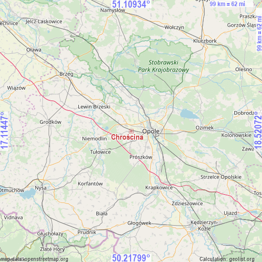
Chrościna GPS coordinates[2]
50° 39' 56.808" North, 17° 49' 3.324" East
| Map corner | latitude | longitude |
|---|---|---|
| Upper-left | 51.10934°, | 17.11447° |
| Center: | 50.66578°, | 17.81759° |
| Lower-right: | 50.21799°, | 18.52072° |
| Map W x H: | 99.1×99.1 km | = 61.6×61.6mi |
| max Lat: | 54.83135° ⇑63.6% North |
| Chrościna: | 50.66578° |
| min Lat: | ⇓36.4% South 49.21328° |
| min Long | Chrościna | max Long |
| 14.20249° | 17.81759° | 24.03723° |
| W 23%⇐ | ⇒77% E |
Elevation
Elevation of Chrościna is 164 m = 538 ft, and this is 27.4 m = 90 ft below average elevation for this country.
| Max E: |
974 m = 3196 ft | 52.9% |
| Avg. | 191.4 m = 628 ft | |
| Chrościna | 164 m = 538 ft | |
Min E: |
-3 m = -10 ft | 47.1% |
See also: Poland elevation on elevation.city.
Geographical zone
Chrościna is located in North temperate zone (between Tropic of Cancer and the Arctic Circle). Distance of this North polar circle is 1767.7 km =1098.4 mi to North.| Distance of | km | miles | from Chrościna |
|---|---|---|---|
| North Pole | 4373.6 | 2717.6 | to North |
| Arctic Circle | 1767.7 | 1098.4 | to North |
| Tropic Cancer | 3027.6 | 1881.3 | to South |
| Equator | 5633.5 | 3500.5 | to South |


Nearby cities:
15 places around Chrościna: (largest is in red/bold)
• Borkowice
11 km =6.8 mi,  319°
319°
• Chmielowice
3.9 km =2.4 mi,  117°
117°
• Chróścice
12.8 km =8 mi,  358°
358°
• Czarnowąsy
9 km =5.6 mi,  39°
39°
• Dobrzeń Wielki
11.6 km =7.2 mi,  10°
10°
• Dąbrowa
5.2 km =3.2 mi,  292°
292°
• Karczów
4.8 km =3 mi,  330°
330°
• Komprachcice
3.3 km =2.1 mi,  169°
169°
• Kąty Opolskie
16.2 km =10.1 mi,  136°
136°
• Niemodlin
14.2 km =8.8 mi,  259°
259°
• Opole
7.6 km =4.7 mi,  84°
84°
• Prószków
10.6 km =6.6 mi,  159°
159°
• Skorogoszcz
14.1 km =8.8 mi, 317°
• Swierkle
13.5 km =8.4 mi, 36°
• Tułowice
14 km =8.7 mi,  236°
236°
Sources, notices
• [Note1] Compared only with cities in Poland existing in our database
• [Src1] Map data: © OpenStreetMap contributors (CC-BY-SA)
• [Src2] Other city data from geonames.org with taken over terms of usage.
• [Src3] Geographical zone / Annual Mean Temperature by Robert A. Rohde @ Wikipedia
