Stargard geodata
Stargard (West Pomerania) is a seat of a second-order administrative division; located in Poland in Europe/Warsaw (GMT+2) time zone. With population of 71,224 people, there are 66 cities with bigger population in this country. Compared to other cities in Poland, 87.8% of cities are located further ↓South; 97.8% of cities are located further →East and 97% of cities have higher elevation than Stargard. Note1


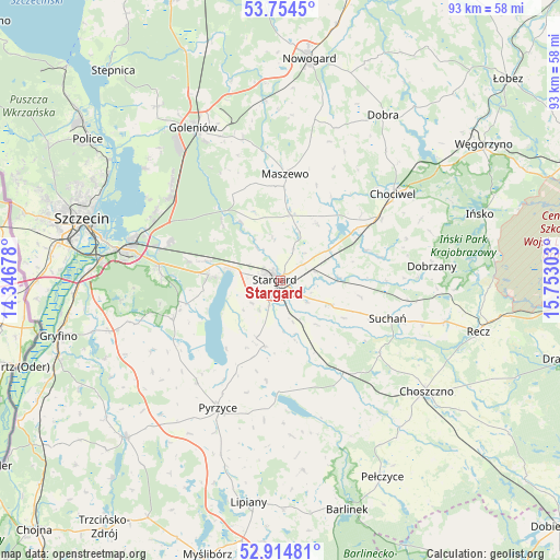
Stargard GPS coordinates[2]
53° 20' 12.192" North, 15° 2' 59.64" East
| Map corner | latitude | longitude |
|---|---|---|
| Upper-left | 53.7545°, | 14.34678° |
| Center: | 53.33672°, | 15.0499° |
| Lower-right: | 52.91481°, | 15.75303° |
| Map W x H: | 93.4×93.4 km | = 58×58mi |
| max Lat: | 54.83135° ⇑12.2% North |
| Stargard: | 53.33672° |
| min Lat: | ⇓87.8% South 49.21328° |
| min Long | Stargard | max Long |
| 14.20249° | 15.0499° | 24.03723° |
| W 2.2%⇐ | ⇒97.8% E |
Elevation
Elevation of Stargard is 21 m = 69 ft, and this is 170.4 m = 559 ft below average elevation for this country.
| Max E: |
974 m = 3196 ft | 97% |
| Avg. | 191.4 m = 628 ft | |
| Stargard | 21 m = 69 ft | |
Min E: |
-3 m = -10 ft | 3% |
See also: Stargard elevation on elevation.city.
Geographical zone
Stargard is located in North temperate zone (between Tropic of Cancer and the Arctic Circle). Distance of this North polar circle is 1470.7 km =913.9 mi to North.| Distance of | km | miles | from Stargard |
|---|---|---|---|
| North Pole | 4076.6 | 2533.1 | to North |
| Arctic Circle | 1470.7 | 913.9 | to North |
| Tropic Cancer | 3324.6 | 2065.8 | to South |
| Equator | 5930.5 | 3685 | to South |


Nearby cities:
15 places around Stargard: (largest is in red/bold)
• Bielice
26.3 km =16.3 mi,  234°
234°
• Chociwel
23.7 km =14.7 mi,  52°
52°
• Dobrzany
25.3 km =15.7 mi,  84°
84°
• Dolice
19.1 km =11.9 mi,  147°
147°
• Kobylanka
11.9 km =7.4 mi,  274°
274°
• Marianowo
15.3 km =9.5 mi,  70°
70°
• Maszewo
17.7 km =11 mi,  2°
2°
• Morzyczyn
8.9 km =5.5 mi,  281°
281°
• Mosty
24.3 km =15.1 mi,  345°
345°
• Przelewice
25.9 km =16.1 mi,  176°
176°
• Pyrzyce
23.6 km =14.7 mi,  206°
206°
• Stara Dąbrowa
11.3 km =7 mi,  33°
33°
• Stare Czarnowo
19.1 km =11.9 mi,  250°
250°
• Suchań
19.4 km =12.1 mi,  109°
109°
• Warnice
9.9 km =6.2 mi,  201°
201°
Sources, notices
• [Note1] Compared only with cities in Poland existing in our database
• [Src1] Map data: © OpenStreetMap contributors (CC-BY-SA)
• [Src2] Other city data from geonames.org with taken over terms of usage.
• [Src3] Geographical zone / Annual Mean Temperature by Robert A. Rohde @ Wikipedia
